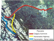
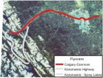
We start our flight on the plains about 30 km east of Calgary and travel westward, over Chestermere Lake and then on to Calgary, where we cross over the junction of the Bow and Elbow rivers in the city's downtown. The flight path then follows the Bow River west to the Rockies. The Trans-Canada Highway can sometimes be seen south (left ) of the river, and Highway 1A to the north. Just west of Calgary lies the Bearspaw Reservoir, which supplies water to the north part of the city. As we move westward, the town of Cochrane, the Ghost Reservoir, and the Ghost River entering the reservoir from the north, come into view. Three geological provinces are traversed in the flyover: the Plains, the Foothills (west of Cochrane) and the Rocky Mountains, which we enter at Lac des Arcs, with Mount Yamnuska on the north (right) side of the river. The flight ends over the mountain town of Canmore, with a view of Mount Rundle to the left.
Flyover by Dave Hughes and Richard Nairn
Small [MPEG, 14.6 Mb]
Large [MPEG, 28.8 Mb]
Note: you will need Windows Media Player to view these flyovers.
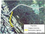
Kananaskis Highway Flyover
This flight begins along the Trans-Canada Highway and follows Highway 40 south along the Front Ranges of the Rocky Mountains into Kannanaskis Country recreational area and Peter Lougheed Provincial Park. First we fly over Barrier Lake, then Fortress Mountain ski area on the west (right) side of the valley and Kananaskis Village, site of the 2002 G8 summit meeting of world leaders. At flight's end, we can see the Kananaskis Lakes in the far distance.
Flyover by Dave Hughes and Richard Nairn
Small [MPEG, 2.8 Mb]
Large [MPEG, 9.7 Mb]
Note: you will need Windows Media Player to view these flyovers.
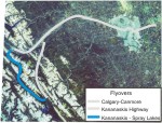
Kananaskis-Spray Lakes Flyover
This flight begins at Lower Kananaskis Lake in Peter Lougheed Provincial Park and takes us northwest within the Front Ranges along the Smith-Dorrien Road and Smith-Dorrien Creek. At its highest point, it crosses over into the Spray Lakes reservoir and canal system, and then plunges down through White Man's Pass into the Bow Valley and the town of Canmore.
Flyover by Dave Hughes and Richard Nairn
Small [MPEG, 4.6 Mb]
Large [MPEG, 16.2 Mb]
Note: you will need Windows Media Player to view these flyovers.