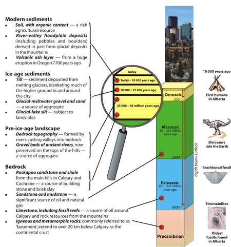
Then... Geological time is divided into four eras (from youngest to oldest): Cenozoic, Mesozoic, Paleozoic, and Precambrian. The main events in the geological story of the Calgary region take place between 544 million years ago (the start of the Paleozoic Era) and the present.
The story begins in the Precambrian, at the bottom of the time scale:
As mountain-building ceased, the inland sea was filled by sediment and elevated. Most of the Cenozoic Era is dominated by river erosion of both the mountains and plains.
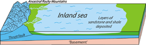
Mesozoic time During Mesozoic time, Paleozoic sedimentary rocks were pushed upward and eastward to form ancestral Rocky Mountains of Himalayan heights, which were then eroded; the sediment was transported by rivers into the inland sea to the east.
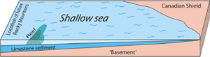
Paleozoic time In Paleozoic time, sediments were deposited upon the Precambrian 'basement' over much of North America in an extension of an ancient Pacific Ocean. Many of these sediments are the products of organic activity and were transformed by burial and compaction to limestone that is rich in fossils, including reefs, like those exposed now in the Rocky Mountains at Canmore.
Precambrian time Precambrian igneous and metamorphic rocks are the ancient foundation of North America, forming the Canadian Shield where they are exposed at the surface in northern Alberta.
...and now
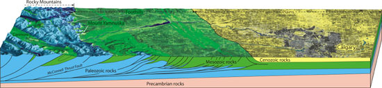
Majestic Mountains
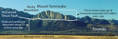
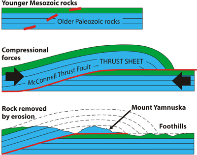
Driving from Calgary to Canmore, it is hard to miss Mount Yamnuska, the most easterly peak north of the Trans-Canada Highway. It is a striking example of Paleozoic limestone, deposited about 520 million years ago, that was thrust on top of younger (Mesozoic) sandstone and shale deposited about 75 million years ago.
The paper-thin contact between the two rock formations is the McConnell Thrust Fault, one of the major faults of the eastern Rocky Mountains.
McConnell thrust fault (Photo: B. Groulx)
Peaceful Plains
The Plains geological province, from Cochrane east to Manitoba, is made of sedimentary rocks not affected by mountain building and lies undeformed upon the original 'basement'.
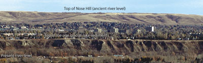
The main hills in the Calgary and Cochrane areas are remnants of a much higher plain from 1 million years ago, that has been largely removed by river erosion. The eroded land surface was modified by glacial erosion during the Ice Age, and the river valleys were the site of sediment deposition as the glaciers melted. Most recently, rivers in the last 10 000 years have cut down through ice-age sediments to their present levels.
Rivers in the last 10 000 years have cut down through ice-age sediments to their present levels.
(Photo: T. Poulton)
Mountain Building
Mountain building
During the building of the Rocky Mountains, from about 160 million to 60 million years ago, huge slabs of Paleozoic sedimentary rock ('thrust sheets') were shifted tens of kilometers northeastward and upward on top of much younger rock formations. Enormous tectonic forces over geological time allowed the rock to move and fold slowly, like a thick fluid.
Millions of years of erosion by water, wind, and ice have removed most of the original mountains, leaving only remnants - high cliffs of far-travelled hard limestone that now sit on top of much younger and softer sandstone and shale. Paleozoic limestone forming a rugged topography defines the Rocky Mountains geological province.
From the Rocky Mountains east to about Cochrane, the soft sandstone and shale of the Mesozoic were also faulted and folded during younger episodes of mountain building. They are not as hard as the limestone of the Rocky Mountains, however, and they have been eroded to form the gentler topography of the Foothills geological province.