CGEN Archive

Geoscape - Calgary

CGEN's Home Page
  • Home
  • CGEN Newsletter
    • CGEN Minutes
  • EarthLinks
  • EdGEO
    • Bringing Earth Science to Life
    • Putting the Earth into Science
  • FBY
    • FBY-Chapter Previews
    • FBY-Sample Lesson
    • QMA-Apercus des chapitres
  • Geoscape
    • Geoscape Canada >
      • Calgary
      • Fort Fraser
      • Montreal
      • Nanaimo
      • Northwest Territories
      • Ottawa-Gatineau
      • Québec
      • Saskatchewan-North
      • Saskatchewan-South
      • Toronto
      • Vancouver
      • Victoria
      • Whitehorse
    • Géopanorama du Canada
    • Geoscape Posters
    • Geotours
    • Waterscapes >
      • Bowen Island
      • Bow River Basin
      • Gulf Islands
      • Okanagan Basin
  • Geovistas
  • Key Publications
    • Wat On Earth
  • OGGP
  • Contact Us
Geoscape - Calgary
  • Home
  • Introduction
  • Landscapes
  • Stable Crust
  • Glacial History
  • Rock Resources
  • Sandstone City
  • Fossil Fuel Energy
  • Slope Stability
  • Rivers...Friend and Foe
  • Groundwater
  • Virtual Tours
  • Credits & Citation
  • Poster Downloads

Geoscape - Calgary

Rivers...Friend and Foe

Water from the Bow and Elbow rivers meets the urban and agricultural needs of much of southern Alberta. Reservoirs along both rivers provide Calgarians with fresh water, and irrigation canals carry water to farms east of Calgary. The rivers also provide a natural retreat within Calgary and attract trout fishermen from around the world.
Floods

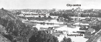
Floods can occur during the summer when exceptionally heavy rainfalls combine with rapid snowmelt in the mountains. In June 1929, flooding on the Elbow River washed out the 25th Avenue SE bridge and created a lake where Victoria Park had been. The last major summer flood to hit Calgary was in 1932, when the Bow River inundated Sunnyside and other communities.

Ice jams form during spring breakup or during Chinook winds in midwinter. They are caused by surface ice breaking into floes, which pile up against obstructions and block the river's flow.
Picture
Bow River summer flood of 1932 (Photo: courtesy of Glenbow Archives)

Future Flooding?

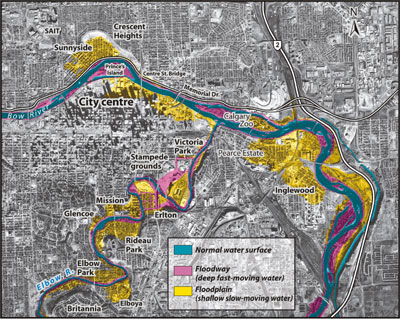
The risk of flood damage has been reduced by the construction of dams on the Bow River upstream from Calgary and of dikes around the floodplain areas of the city. However, the dams are too far upstream and the storage capacity of the reservoirs is too small to prevent the largest spring or summer floods. A 1996 estimate of the damage to Calgary resulting from a '100-year flood' (a flood that has 1 chance in 100 of occurring in any given year) is $131 million.
Picture
Flood zones of the 100-year flood. (Airphoto: courtesy Alberta Sustainable Resource Development Floodzones: City of Calgary)
Géopanorama du Canada
Geoscapes:
  • Canada
  • Calgary
  • Fort Fraser
  • Montreal
  • Nanaimo
  • Northwest Territories
  • Ottawa-Gatineau
  • Québec
  • Saskatchewan - North
  • Saskatchewan - South
  • Toronto
  • Vancouver
  • Victoria
  • Whitehorse

Copyright CGEN 2014-2020
​ Quick Links to Earth Sciences Canada sites
​Earthlinks | WHERE Challenge | Careers in Earth Science |  Four Billion Years and Counting | IYPE | CFES | CGEN | IUGS | GeoVistas | OGGP