CGEN Archive

Geoscape Canada

English  |  Francais

CGEN's Home Page
  • Home
  • CGEN Minutes
  • EarthLinks
  • EdGEO
    • Bringing Earth Science to Life
    • Putting the Earth into Science
  • FBY
    • FBY-Chapter Previews
    • FBY-Sample Lesson
    • QMA-Apercus des chapitres
  • Geoscape
    • Geoscape Canada >
      • Calgary
      • Fort Fraser
      • Montreal
      • Nanaimo
      • Northwest Territories
      • Ottawa-Gatineau
      • Québec
      • Saskatchewan-North
      • Saskatchewan-South
      • Toronto
      • Vancouver
      • Victoria
      • Whitehorse
    • Géopanorama du Canada
    • Geoscape Posters
    • Geotours
    • Waterscapes >
      • Bowen Island
      • Bow River Basin
      • Gulf Islands
      • Okanagan Basin
  • Geovistas
  • Key Publications
    • Wat On Earth
  • OGGP
  • Contact Us

About Geoscape Canada

The Geoscapes are a series of posters and resources materials for use by educators and communities, to help increase awareness and understanding of the role of the geosciences in our lives. They range from Geoscape posters and associated resources, Waterscapes which focus on water as an important resource for all of us, to Geovistas which combine engaging descriptions of geological features in the landscape with information on how they have influenced climate, ecology and culture.  All of these resources were developed by the Geological Survey of Canada in collaboration with communities, provincial and territorial surveys as well as interested geoscientists and educators across the country.

Why?

To increase awareness of the important role that geoscience plays in all of our lives  and to better inform Canadians about important geoscience issues in their communities.

Why?

People protect what they know. Canadian communities can be more sustainable if they understand their local geoscape, or geological landscape - their water resources, natural hazards, earth resources, and environmental services. 

Benefits include:
  • protection of groundwater and surface water supplies
  • mitigation of natural hazards such as floods, landslides, earthquakes, radon
  • development of earth resources such as aggregate and minerals
  • protection of natural services provided by soils, streams, and wetlands

Who?

Geoscape Canada is led by the Geological Survey of Canada of Natural Resources Canada in partnership with provincial and municipal agencies and educators across the country.


Geoscape Poster Downloads...

Picture
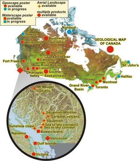
The maps and panels produced for this project explain the landscapes, earth and water resources, and natural hazards of Canadian communities.
Picture
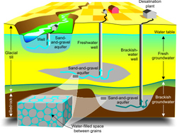
natural aquifers and water resourcers
Picture
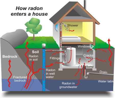
Radon can enter a house in many ways, such as through groundwater, well water, and the soil.
Géopanorama du Canada
Geoscapes:
  • Canada
  • Calgary
  • Fort Fraser
  • Montreal
  • Nanaimo
  • Northwest Territories
  • Ottawa-Gatineau
  • Québec
  • Saskatchewan - North
  • Saskatchewan - South
  • Toronto
  • Vancouver
  • Victoria
  • Whitehorse 

Other Geoscapes:
  • Edmonton (pdf file)
  • Grand River...
    article / presentation
  • Nunavut (Geoscan links)
    English​ / French


Government of Canada Copyright Notice
Archived Content Notice: The original archive site no longer exists. These publications are provided for reference, research or record-keeping purposes. Please note the adoption of the Open Government Licence - Canada supersedes any previous licences. 
Contenu archivé: ​Le site d'archive d'origine n'existe plus. Ces publications sont fournie à des fins de référence, de recherche ou de tenue de documents. Veuillez noter que la Licence du gouvernement ouvert - Canada remplace toutes les licences antérieures.
Copyright CGEN 2014-2021
​ Quick Links to Earth Sciences Canada sites
​Earthlinks | WHERE Challenge | Careers in Earth Science |  Four Billion Years and Counting | IYPE | CFES | CGEN | IUGS | GeoVistas | OGGP