CGEN Archive

Geoscape - Calgary

CGEN's Home Page
  • Home
  • CGEN Minutes
  • EarthLinks
  • EdGEO
    • Bringing Earth Science to Life
    • Putting the Earth into Science
  • FBY
    • FBY-Chapter Previews
    • FBY-Sample Lesson
    • QMA-Apercus des chapitres
  • Geoscape
    • Geoscape Canada >
      • Calgary
      • Fort Fraser
      • Montreal
      • Nanaimo
      • Northwest Territories
      • Ottawa-Gatineau
      • Québec
      • Saskatchewan-North
      • Saskatchewan-South
      • Toronto
      • Vancouver
      • Victoria
      • Whitehorse
    • Géopanorama du Canada
    • Geoscape Posters
    • Geotours
    • Waterscapes >
      • Bowen Island
      • Bow River Basin
      • Gulf Islands
      • Okanagan Basin
  • Geovistas
  • Key Publications
    • Wat On Earth
  • OGGP
  • Contact Us
Geoscape - Calgary
  • Home
  • Introduction
  • Landscapes
  • Stable Crust
  • Glacial History
  • Rock Resources
  • Sandstone City
  • Fossil Fuel Energy
  • Slope Stability
  • Rivers...Friend and Foe
  • Groundwater
  • Virtual Tours
  • Credits & Citation
  • Poster Downloads

Geoscape - Calgary

Geoscape Calgary Poster
Download Poster [PDF, 9.2 Mb]

Picture
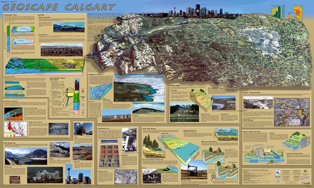
The Geoscape Calgary poster uses over 30 diagrams, maps, and pictures in an attractive and colourful presentation of Earth materials and processes that have shaped Calgary's geological landscape, or Geoscape.

This product is intended not only to explain geological phenomena, but also to illustrate why we need an understanding of our geological landscape to make sustainable land-use decisions for Calgary's growing population.

Downloads for Teachers:
  • Small image of poster [JPEG, 1.3 Mb, 1500 X 900]
  • PowerPoint slide presentation [ZIP, 4.4 Mb]
  • Viewing copy of the poster [PDF, 9.2 Mb]

Satellite Image of Calgary

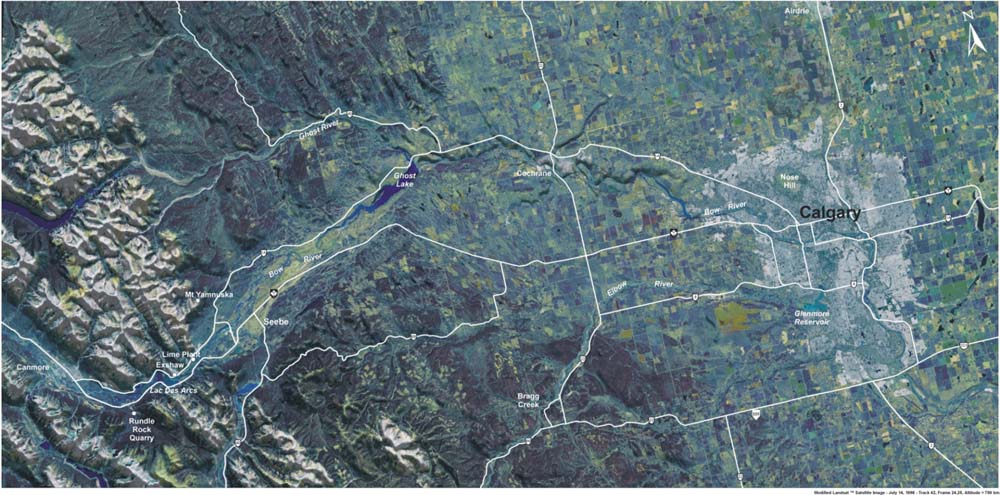
The Geoscape Calgary area comprises the city of Calgary and its hinterland to the west, including Canmore and the Bow Valley, as well as Bragg Creek along the Elbow River Valley.

View the satellite image below or watch the video flyovers to view the area that comprises Geoscape Calgary.
Picture
Satellite image of Geoscape Calgary area
larger image [JPEG, 126.2 kb, 1000 X 495]

Want to know more?

Additional reading:

Huck B. and Whiteway, D., 1998. In Search of Ancient Alberta; Heartland Associates Inc.

Karrow, P. and White, O. (ed.), 1998. The Urban Geology of Canadian Cities; The Geological Association of Canada, Special Paper 42.

Mussieux, R. and Nelson, M., 1998. A Traveller's Guide to Geological Wonders in Alberta; The Provincial Museum of Alberta.
Géopanorama du Canada
Geoscapes:
  • Canada
  • Calgary
  • Fort Fraser
  • Montreal
  • Nanaimo
  • Northwest Territories
  • Ottawa-Gatineau
  • Québec
  • Saskatchewan - North
  • Saskatchewan - South
  • Toronto
  • Vancouver
  • Victoria
  • Whitehorse
Copyright CGEN 2014-2021
​ Quick Links to Earth Sciences Canada sites
​Earthlinks | WHERE Challenge | Careers in Earth Science |  Four Billion Years and Counting | IYPE | CFES | CGEN | IUGS | GeoVistas | OGGP