CGEN Archive

Geoscape - Calgary

CGEN's Home Page
  • Home
  • CGEN Newsletter
    • CGEN Minutes
  • EarthLinks
  • EdGEO
    • Bringing Earth Science to Life
    • Putting the Earth into Science
  • FBY
    • FBY-Chapter Previews
    • FBY-Sample Lesson
    • QMA-Apercus des chapitres
  • Geoscape
    • Geoscape Canada >
      • Calgary
      • Fort Fraser
      • Montreal
      • Nanaimo
      • Northwest Territories
      • Ottawa-Gatineau
      • Québec
      • Saskatchewan-North
      • Saskatchewan-South
      • Toronto
      • Vancouver
      • Victoria
      • Whitehorse
    • Géopanorama du Canada
    • Geoscape Posters
    • Geotours
    • Waterscapes >
      • Bowen Island
      • Bow River Basin
      • Gulf Islands
      • Okanagan Basin
  • Geovistas
  • Key Publications
    • Wat On Earth
  • OGGP
  • Contact Us
Geoscape - Calgary
  • Home
  • Introduction
  • Landscapes
  • Stable Crust
  • Glacial History
  • Rock Resources
  • Sandstone City
  • Fossil Fuel Energy
  • Slope Stability
  • Rivers...Friend and Foe
  • Groundwater
  • Virtual Tours
  • Credits & Citation
  • Poster Downloads

Geoscape - Calgary

Groundwater

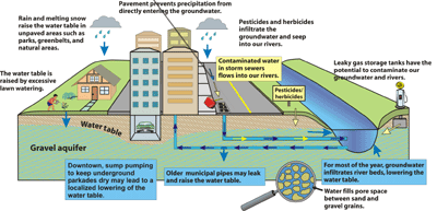
Groundwater is something that few people think about. This abundant resource, however, is directly linked to our surface water supply in the Calgary valleys. When river levels are high, groundwater flows into the surrounding gravels, and during the rest of the year groundwater flows into the riverbeds. Because of this interconnection, contamination of either will affect the entire system. Sources of contamination within Calgary include leaky gas station fuel tanks, industrial activity, herbicides, pesticides, surface water runoff, and irresponsible storm sewer use.
Aquifers

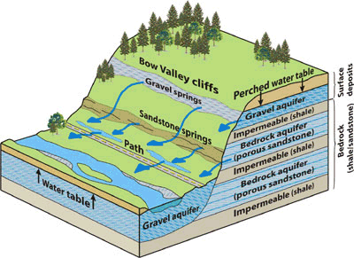
An aquifer is a body of bedrock or sediment that yields water in usable quantities. Although some groundwater occurs in Calgary's sandstone bedrock, the city's major aquifer is the gravel that lines the Bow and Elbow river valleys. Groundwater is stored in pores between grains of sediment.

Picture
Groundwater under Calgary
Springs and Slippery Paths

Springs occur where gravel or bedrock aquifers intersect the ground surface. One community in northwest Calgary, Silver Springs, takes its name from springs along the north side of the Bow River.

Some springs have proven to be an annual problem in Calgary. At the base of Spruce Cliff, southeast of Edworthy Park, water from numerous springs flows in small streams down to the Bow River, crossing a pedestrian and bicycle path. In winter the ice from these streams may build up to almost 2 m thick on parts of the path, making springtime walking and biking treacherous.
Picture
Springs
Géopanorama du Canada
Geoscapes:
  • Canada
  • Calgary
  • Fort Fraser
  • Montreal
  • Nanaimo
  • Northwest Territories
  • Ottawa-Gatineau
  • Québec
  • Saskatchewan - North
  • Saskatchewan - South
  • Toronto
  • Vancouver
  • Victoria
  • Whitehorse

Copyright CGEN 2014-2020
​ Quick Links to Earth Sciences Canada sites
​Earthlinks | WHERE Challenge | Careers in Earth Science |  Four Billion Years and Counting | IYPE | CFES | CGEN | IUGS | GeoVistas | OGGP