CGEN Archive

Waterscape Canada

CGEN's Home Page
  • Home
  • CGEN Minutes
  • EarthLinks
  • EdGEO
    • Bringing Earth Science to Life
    • Putting the Earth into Science
  • FBY
    • FBY-Chapter Previews
    • FBY-Sample Lesson
    • QMA-Apercus des chapitres
  • Geoscape
    • Geoscape Canada >
      • Calgary
      • Fort Fraser
      • Montreal
      • Nanaimo
      • Northwest Territories
      • Ottawa-Gatineau
      • Québec
      • Saskatchewan-North
      • Saskatchewan-South
      • Toronto
      • Vancouver
      • Victoria
      • Whitehorse
    • Géopanorama du Canada
    • Geoscape Posters
    • Geotours
    • Waterscapes >
      • Bowen Island
      • Bow River Basin
      • Gulf Islands
      • Okanagan Basin
  • Geovistas
  • Key Publications
    • Wat On Earth
  • OGGP
  • Contact Us

Waterscape - Okanagan Basin

Hydropanoramas
  • Home
  • From Highlands
  • Our Water Cycle
  • Our Lakes
  • Groundwater
  • Our Changing Climate
  • Protecting Water Needs
  • We Need Healthy Streams
  • Irrigation
  • Wise Water Use Indoors
  • Wise Water Use Outdoors
  • Sharing Our Waters
  • Credits & Citation
  • Poster Downloads


Picture
larger image
[JPEG, 5.8 Mb, 4000 X 5692]
​

Download Poster  [PDF, 21.5 Mb]

Water - the myth of abundance

The Okanagan Basin is our home, a very special place. It has been home to First Nations peoples for thousands of years, and to many others over the last century and a half. Water has always been the basin's most valuable resource for both humans and nature. Today, our economy, agriculture, home use, and recreation continue to share these waters with nature.
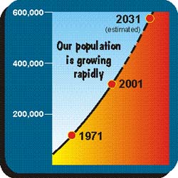
We live in a dry landscape. The large lakes make water look abundant, but nature's yearly resupply is small. As our population is growing rapidly, so is our demand for water. Climate is changing and future water supplies are uncertain. Will there be enough water for our children and grandchildren? To meet the needs of humans and nature, we will have to rethink our water use, and value it more highly.

Picture
Okanagan Basin
Picture
Our population is growing rapidly
Picture
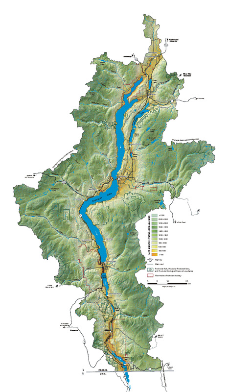
What is the Okanagan Basin?

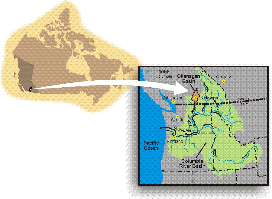
A river basin or watershed is high at its edges and low in the centre where the waters flow. The Okanagan Basin includes all the land that feeds water to our big lakes. Kelowna, Vernon, Penticton, and Osoyoos all lie within the Okanagan Basin. The Okanagan River drains the lakes and flows south across the International Boundary as a small tributary to the Columbia River.
Where does water from the Okanagan Basin go?
Okanagan Basin water flows into the Columbia River, past the city of Portland, to the Pacific Ocean.
Waterscapes:
  • Bowen Island 
  • Bow River Basin
  • Gulf Islands
  • Okanagan Basin ​
Copyright CGEN 2014-2021
​ Quick Links to Earth Sciences Canada sites
​Earthlinks | WHERE Challenge | Careers in Earth Science |  Four Billion Years and Counting | IYPE | CFES | CGEN | IUGS | GeoVistas | OGGP