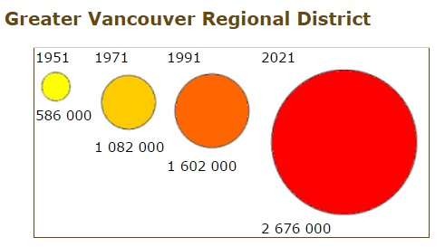
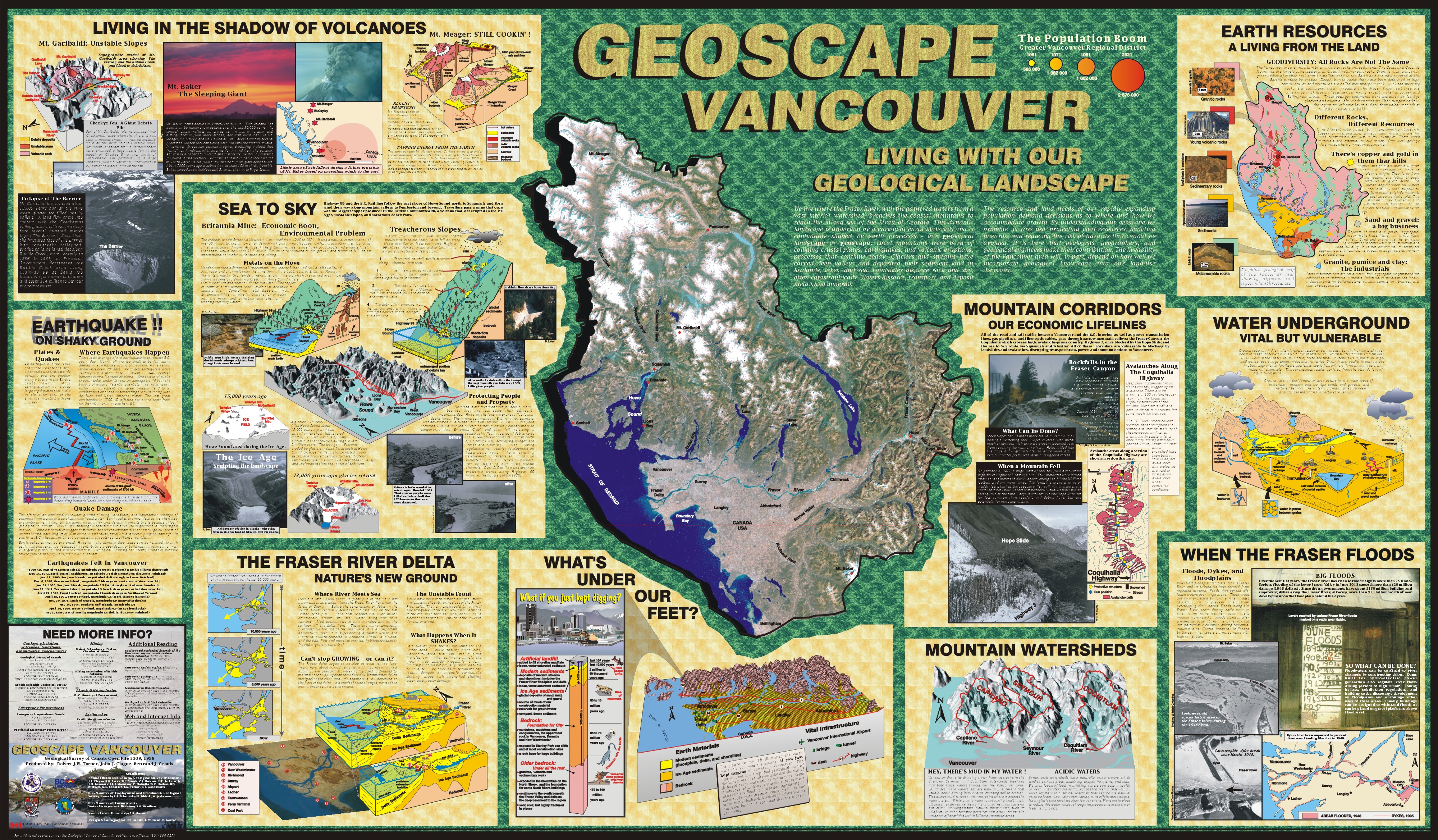
We live where the Fraser River, with the gathered waters from a vast interior watershed, breaches the coastal mountains to reach the inland sea of the Strait of Georgia. This dynamic landscape is underlain by a variety of earth materials and is continually shaped by earth processes - our geological landscape or geoscape. Local mountains were born of colliding crustal plates, earthquakes, and volcanic eruptions, processes that continue today. Glaciers and streams have carved deep valleys and deposited their sediment load in lowlands, lakes, and sea. Landslides displace rock and soil, often catastrophically. Waters dissolve, transport, and deposit metals and minerals.
The Population Boom
The resource and land needs of our rapidly expanding population demand decisions as to where and how we accommodate growth. By understanding our geoscape we promote its wise use: protecting vital resources, avoiding hazards, and reducing the risk of hazards that cannot be avoided. It is here that geologists, geographers, and geological engineers make their contribution. The liveability of the Vancouver area will, in part, depend on how well we incorporate geological knowledge into our land-use decisions.
Provincial Emergency Program (PEP) 605 1200 W. 73rd Ave. Vancouver, B.C. V6P 6G5 Enquiries: (604) 660-3723
Mining
British Columbia and Yukon Chamber of Mines 840 West Hastings St. Vancouver, B.C. V6C 1C8 Enquiries: (604) 681-5328
Mining Association of British Columbia 840 West Hastings Street Vancouver, B.C. V6C 1C8 Enquiries: (604) 681-4321
Floods & Groundwater
B. C. Ministry of Environment Water Management Division 10334 - 152A Street Surrey, B.C. V3R 7P8 Enquiries: 1-800-665-7027
Earthquakes
Pacific Geoscience Centre Geological Survey of Canada Natural Resources Canada P.O. Box 6000 Sidney, B.C. V8L 4B2 Enquiries: (604) 363-6500
Additional Reading
Geology and geological hazards of the Vancouver region, southwestern British Columbia. Edited by J.W.H. Monger. 1994, Geological Survey of Canada Bulletin 481
Vancouver and its region. Edited by G. Wynn and T. Oke. 1992, UBC Press
Vancouver geology. J.E. Armstrong. 1990, Geological Association of Canada, Cordilleran Section
Landslides in British Columbia. Information Circular 1993-7. B.C. Ministry of Employment and Investment, Geological Survey Branch
Earthquakes in British Columbia. Information Circular 1991-6. B.C. Ministry of Employment and Investment, Geological Survey Branch
Related Projects
Urban Geology Urban geology provides engineers, planners, decision makers, and the general public with the geoscience information required for sound regional planning in densely populated areas. Urban geology studies rely on diverse branches of earth sciences such as hydrology, engineering geology, geochemistry, stratigraphy, and geomorphology in order to build a three-dimensional model of the character of the land and to explain the geological processes involved in the dynamic equilibrium of the local environment. The geoscience information derived from various sources such as borehole logs, geological maps, hydrological reports and digital elevation models, is compiled in a digital format and stored in georeferenced databases in the form of point, linear, and polygonal data. This information constitutes the geoscience knowledge base which is then processed by Geographic Information Systems (GIS) to integrate the various sources of information and produce derived graphics, maps and models describing the geological infrastructure and response of the geological environment to human activities.
