CGEN Archive

Geoscape - Vancouver

CGEN's Home Page
  • Home
  • CGEN Newsletter
    • CGEN Minutes
  • EarthLinks
  • EdGEO
    • Bringing Earth Science to Life
    • Putting the Earth into Science
  • FBY
    • FBY-Chapter Previews
    • FBY-Sample Lesson
    • QMA-Apercus des chapitres
  • Geoscape
    • Geoscape Canada >
      • Calgary
      • Fort Fraser
      • Montreal
      • Nanaimo
      • Northwest Territories
      • Ottawa-Gatineau
      • Québec
      • Saskatchewan-North
      • Saskatchewan-South
      • Toronto
      • Vancouver
      • Victoria
      • Whitehorse
    • Géopanorama du Canada
    • Geoscape Posters
    • Geotours
    • Waterscapes >
      • Bowen Island
      • Bow River Basin
      • Gulf Islands
      • Okanagan Basin
  • Geovistas
  • Key Publications
    • Wat On Earth
  • OGGP
  • Contact Us
Geoscape - Vancouver
  • Home
  • In the Shadow of Volcanoes
  • Sea to Sky
  • The Fraser River Delta
  • Earthquake!!
  • Earth Resources
  • Mountain Corridors
  • Water Underground
  • When the Fraser Floods
  • Mountain Watersheds 
  • Credits & Citation
  • Poster Downloads
And...
  • Aerial Landscapes
  • Geomap Vancouver
  • Vancouver's Landscape
  • Vancouver Rocks

Geoscape - Vancouver

  • When the Fraser Floods

Floods, Dykes, and Floodplains

River flats (floodplains) adjacent to the Fraser River and its tributaries have formed from repeated seasonal floods that spread silt-laden waters over large areas. These areas are now protected by long earthen ridges (dykes), built to prevent rivers from overtopping their banks. Floods along the Fraser River occur during early summer when warm rainy weather rapidly melts mountain snowpacks. Floods along smaller streams can occur at any time of the year, but are particularly common during torrential autumn rains. Coastal areas can be flooded by the sea when severe storms coincide with high winter tides.
Picture
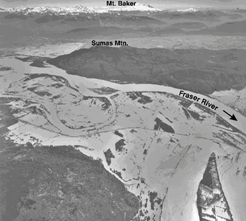
Looking south across Hatzic area in the Fraser Valley during the 1948 flood
Picture
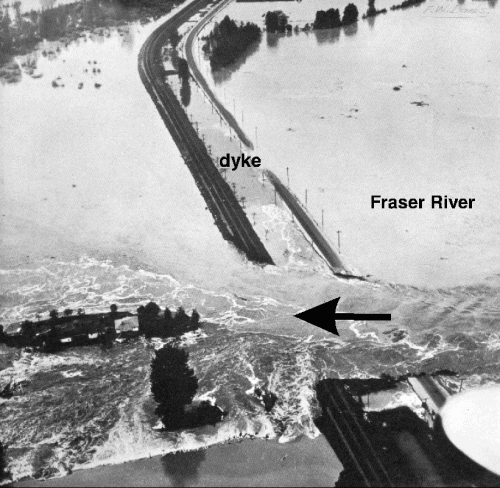
Catastrophic dyke break near Hatzic, 1948.
Picture
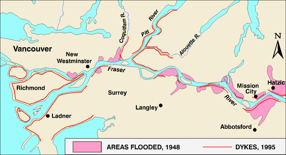
Dykes have been improved to prevent disastrous flooding like that in 1948.

Big Floods

Over the last 100 years, the Fraser River has risen to flood heights more than 25 times. Serious flooding of the lower Fraser Valley in June 1948 caused more than $20 million damage (1948 dollars). Since then, governments have spent $160 million building and improving dykes along the Fraser River, allowing more than $13 billion worth of new development on the floodplain behind the dykes.
Picture
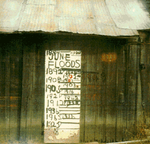
Levels reached by various Fraser River floods marked on a cabin near Hatzic.


So What Can Be Done?

Floodwaters can be confined to river channels by constructing dykes. Dams built for hydro-electric power generation also regulate river flows during periods of high runoff. Zoning by-laws, subdivision regulations, and building codes discourage development on floodplains and encourage other uses of these areas. Finally, buildings can be designed to withstand floods or can be placed on gravel platforms above flood level.
Géopanorama du Canada
Geoscapes:
  • Canada
  • Calgary
  • Fort Fraser
  • Montreal
  • Nanaimo
  • Northwest Territories
  • Ottawa-Gatineau
  • Québec
  • Saskatchewan - North
  • Saskatchewan - South
  • Toronto
  • Vancouver
  • Victoria
  • Whitehorse
Copyright CGEN 2014-2020
​ Quick Links to Earth Sciences Canada sites
​Earthlinks | WHERE Challenge | Careers in Earth Science |  Four Billion Years and Counting | IYPE | CFES | CGEN | IUGS | GeoVistas | OGGP