CGEN Archive

Geoscape - Vancouver

CGEN's Home Page
  • Home
  • CGEN Minutes
  • EarthLinks
  • EdGEO
    • Bringing Earth Science to Life
    • Putting the Earth into Science
  • FBY
    • FBY-Chapter Previews
    • FBY-Sample Lesson
    • QMA-Apercus des chapitres
  • Geoscape
    • Geoscape Canada >
      • Calgary
      • Fort Fraser
      • Montreal
      • Nanaimo
      • Northwest Territories
      • Ottawa-Gatineau
      • Québec
      • Saskatchewan-North
      • Saskatchewan-South
      • Toronto
      • Vancouver
      • Victoria
      • Whitehorse
    • Géopanorama du Canada
    • Geoscape Posters
    • Geotours
    • Waterscapes >
      • Bowen Island
      • Bow River Basin
      • Gulf Islands
      • Okanagan Basin
  • Geovistas
  • Key Publications
    • Wat On Earth
  • OGGP
  • Contact Us
Geoscape - Vancouver
  • Home
  • In the Shadow of Volcanoes
  • Sea to Sky
  • The Fraser River Delta
  • Earthquake!!
  • Earth Resources
  • Mountain Corridors
  • Water Underground
  • When the Fraser Floods
  • Mountain Watersheds 
  • Credits & Citation
  • Poster Downloads
And...
  • Aerial Landscapes
  • Geomap Vancouver
  • Vancouver's Landscape
  • Vancouver Rocks

Geoscape - Vancouver

  • Mountain Watersheds

Picture
Hey, there's mud in my water!

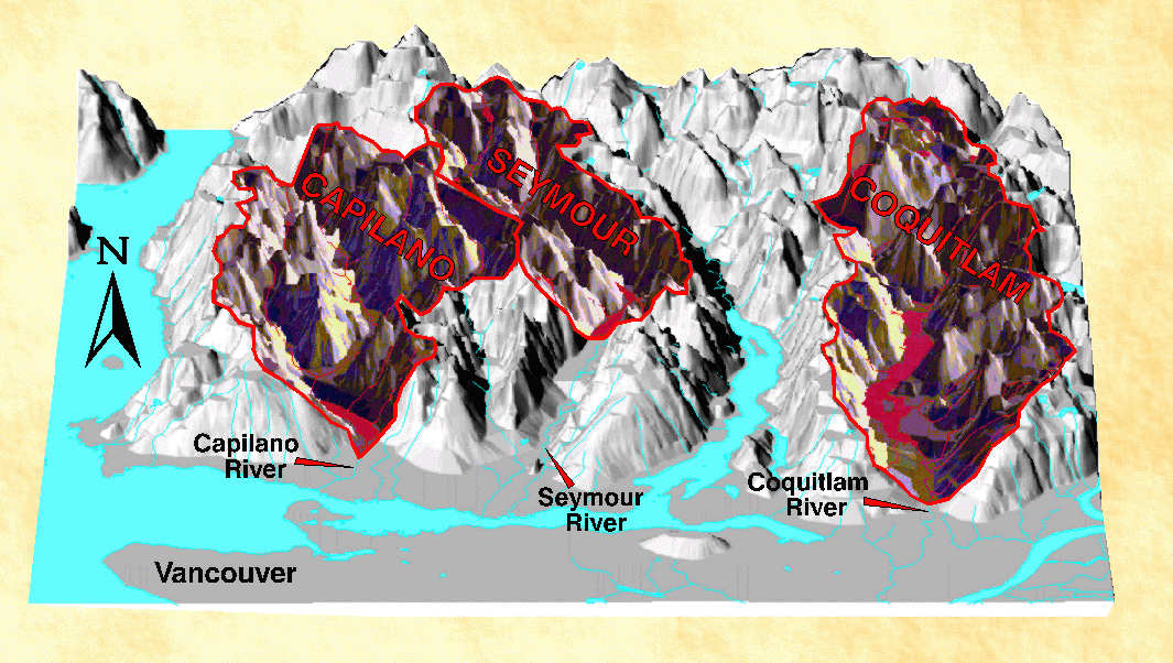
Vancouver draws its drinking water from reservoirs in the Capilano, Seymour, and Coquitlam watersheds. Pipelines distribute these waters throughout the Vancouver area. Landslides in the watersheds are natural phenomena that usually occur during heavy rains, exposing soil to erosion. This allows mud to wash into reservoirs where it enters the water system. While cloudy water is not itself a health risk, silt and clay can reduce the ability of chlorine to kill bacteria and other microorganisms. Natural phenomena, such as wildfires, or poor forestry practices can also increase the incidence of landslides within B.C.'s mountainous areas.

Acidic Waters

Vancouver's watersheds have naturally acidic waters which tend to corrode pipes, dissolving copper, iron, zinc, and lead. Elevated levels of lead in drinking waters can pose a health concern. The waters are acidic because the area is underlain by rocks resistant to chemical reactions that reduce the natural acidity of rain. Also, rainwater rapidly runs off the steep slopes, leaving little time for these chemical reactions. Plans are in place to reduce this water acidity through improvements in the water treatment process.
Géopanorama du Canada
Geoscapes:
  • Canada
  • Calgary
  • Fort Fraser
  • Montreal
  • Nanaimo
  • Northwest Territories
  • Ottawa-Gatineau
  • Québec
  • Saskatchewan - North
  • Saskatchewan - South
  • Toronto
  • Vancouver
  • Victoria
  • Whitehorse
Copyright CGEN 2014-2021
​ Quick Links to Earth Sciences Canada sites
​Earthlinks | WHERE Challenge | Careers in Earth Science |  Four Billion Years and Counting | IYPE | CFES | CGEN | IUGS | GeoVistas | OGGP