Vancouver's landscape -- the land surface of the Vancouver metropolitan area -- has formed through the action of diverse natural processes operating over the vast expanse of geological time. Many of the photographs surrounding the central shaded-relief map show natural processes that are slowly modifying the land surface and that impose important constraints on land use. Other photographs illustrate elements of the geological history of the Vancouver area that can be read from this landscape.
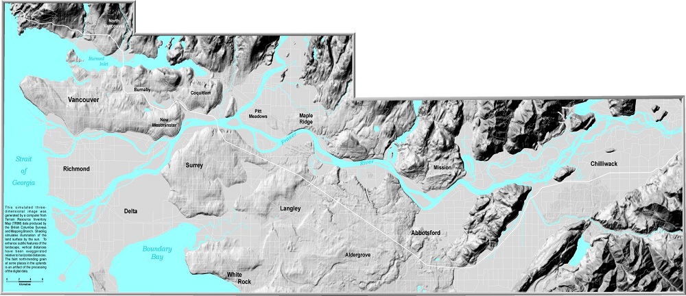
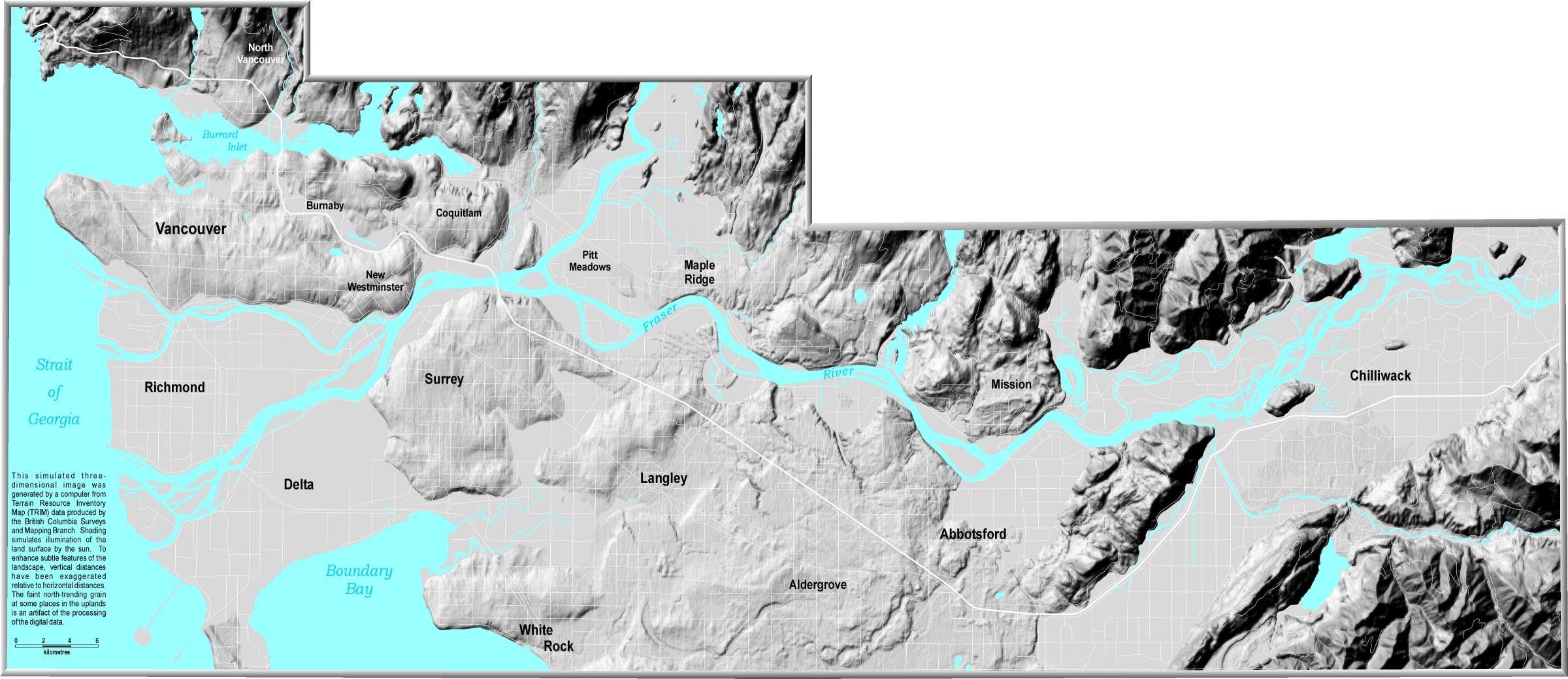
This simulated three-dimensional image was generated by a computer from Terrain Resource Inventory Map (TRIM) data produced by the British Columbia Surveys and Mapping Branch. Shading simulates illumination of the land surface by the sun. To enhance subtle features of the landscape, vertical distances have been exaggerated relative to horizontal distances. The faint north-trending grain at some places in the uplands is an artifact of the processing of the digital data.
Vancouver's Landscape John J. Clague, Robert J. Turner, Kazuharu Shimamura GSC Open File 3722
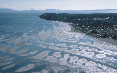
Author: Bob Turner
2. Physiography
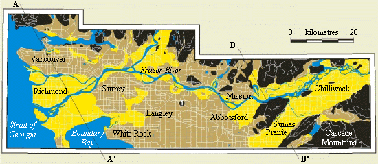
Physiography is the surface form of the Earth. The Vancouver region includes three main physiographic areas. Mountains (Coast and Cascade Mountains) comprise rugged bedrock ridges and peaks and intervening steep-walled valleys. The larger valleys contain thick deposits of sediments and host major rivers, lakes, or arms of the sea (e.g. Howe Sound). The other two physiographic areas are within the Fraser Valley: gently rolling uplands, ranging from about 15 m to 250 m above sea level, are underlain by thick Ice Age (Pleistocene) sediments, largely of glacial origin; flat lowlands along the Fraser River and its tributaries are underlain by modern (Holocene) sediments less than 10,000 years old.
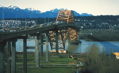
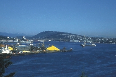
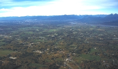
Photo 16
The three primary physiographic elements of the Vancouver area are visible in this photo taken near the south end of the Port Mann Bridge.
The floodplain of the Fraser River, in the foreground, is a lowland area. In the middle distance, beyond the bridge, is a rolling, Ice Age upland on which Coquitlam is located. In the far distance are the southernmost peaks of the Coast Mountains, part of the mountain physiographic area.
Physiography is the surface form of the Earth. The Vancouver region includes three main physiographic areas. Mountain areas (Coast and Cascade Mountains) comprise rugged bedrock ridges and peaks and intervening steep-walled valleys. The larger valleys contain thick modern and Ice Age sediments and also host large lakes and streams. The other two physiographic areas are within the Fraser Valley. Higher parts of the Fraser Valley are gently rolling uplands, ranging from about 15 m to 250 m above sea level. Uplands are underlain by thick Ice Age sediments, largely of glacial origin. Flat lowlands occur along the Fraser River and its tributaries and are underlain by modern sediments.
3. Coast Mountains and Vancouver
The Coast Mountains rise out of the Fraser Valley and extend northward along the coast to Alaska. Near Vancouver they consist mainly of granitic and metamorphic rocks more than 100 million years old. Younger sandstones, about 85 to 35 million years old, overlie these rocks and form many of the hills in Vancouver and Burnaby.
The southern Coast Mountains were created by compression, heating, and uplift, stemming from subduction (undersliding) of Pacific Ocean crust beneath North America. Their present form, however, owes much to erosion. Deep U-shaped valleys, such as the Capilano and Seymour, were carved rivers and modified by glaciers. These valleys contain thick fills of Ice Age and modern sediments. Mountain slopes and peaks have only thin, discontinuous veneers of sediment. Slopes below about 1500 m elevation are somewhat smoothed and rounded due to their having been overridden by the Cordilleran ice sheet which covered nearly all of south-coastal British Columbia as recently as 15,000 years ago. The highest peaks projected through this ice sheet and are more jagged.
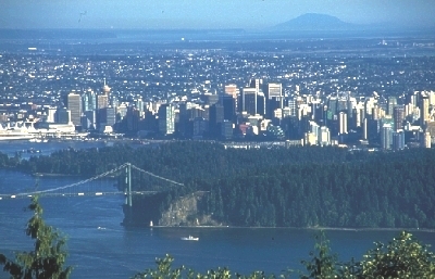
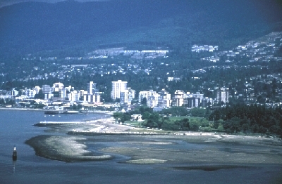
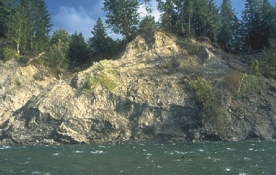
Photo 10 View of Stanley Park and downtown Vancouver from West Vancouver. Stanley Park is underlain by south-tilted layers of sandstone, which are visible along the Stanley Park seawall. Resistant volcanic rock (basalt) forms the steep cliff at Prospect Point near the south end of the Lions Gate Bridge.
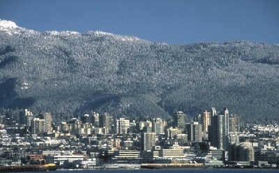
Photo 11 Bedrock slopes of the Coast Mountains rise sharply above North Vancouver, which is built on an upland underlain mainly by Ice Age gravel and sand. View from Stanley Park.
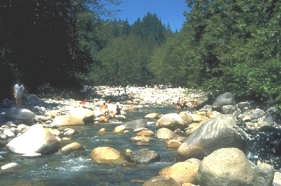
Photo 12 The bouldery channel of Lynn Creek, a typical North Shore mountain stream. Steep-gradient streams such as this transport gravel, even boulders, during floods.
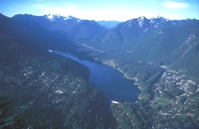
Photo 13 Capilano Lake is one of three reservoirs that provide water to Vancouver. The lake fills the lower part of a large, glacier-carved valley. Cleveland Dam, which impounds the lake, straddles the head of a deep, narrow canyon that has been cut into bedrock by the Capilano River.
Photo 14 Downtown Vancouver is built on a ridge of sandstone tilted gently to the south. To the north, soft mudstone has been more deeply eroded to form Burrard Inlet.
Photo 15 Burnaby Mountain; view east from the Lions Gate Bridge. This mountain is formed of layers of resistant conglomerate and sandstone tilted about 10o to the south. The tilted layering is responsible for the striking asymmetry of the mountain.
Photo 17 Delta at the mouth of the Capilano River. Since construction of Cleveland Dam, Capilano Lake has trapped sediment that would otherwise be transported to the river mouth. A new delta is forming where Capilano River flows into Capilano Lake.
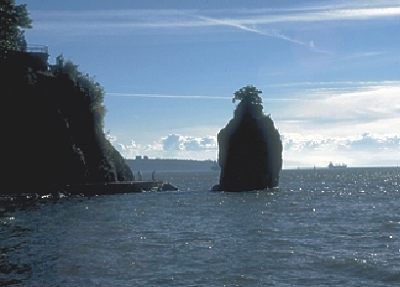
Photo 18 Siwash Rock, a Vancouver landmark. This pillar-like rock was once part of Stanley Park, but became separated from it through erosion by waves and weathering. Siwash Rock remains today because it consists mainly of basalt which is more resistant to erosion than surrounding sandstone.
4. Cascade Mountains The Cascade Mountains, in southeastern corner of the map area, consist mainly of metamorphosed sedimentary and volcanic rocks. Thick Ice Age and modern sediments underlie the larger valleys in these mountains.
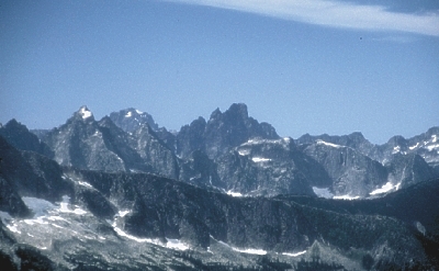
Photo 22 Rugged, high peaks of the Cascade Mountains stood above the surface of the ancient ice sheet that covered British Columbia and therefore have retained their craggy shape. In contrast, the lower, rounded ridge in the foreground was overridden and eroded by the flowing ice.
Photo 27 Landslides are common along the banks of the Chilliwack River. Most of the landslides involve unstable Ice Age sediments and occur during heavy rains. Landslides contribute large amounts of sediment to the river, filling its channels and increasing the risk of downstream flooding.
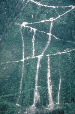
Photo 28 Aerial view of a steep logged slope in the Cascade Mountains near Wahleach Lake. Several landslides moved down this slope during a heavy rainstorm. The landslides were caused by the failure of logging road embankment materials. Landslides are common in our coastal mountains both on logged and unlogged slopes.
Photo 29 Chilliwack River at Vedder Crossing. Chilliwack River transports large amounts of sediment, including gravel which forms the river bars at Vedder Crossing. The river has a history of damaging floods, most of which occur during heavy autumn rainstorms.
5. Sumas Prairie
Photo 25 Sumas Prairie is a flat, poorly drained area, only 5 to 10 m above sea level, between Sumas and Vedder mountains. Faults at the base of Sumas and Vedder mountains form a basin containing several hundred metres of sediments. The upper sediments are less than 10,000 years old and accumulated in an ancient lake. The historic remnant of this lake, known as Sumas Lake, covered an area of many square kilometres and existed until the 1920s, when it was drained to create new agricultural land. Were it not for dykes along the Fraser and Vedder (Chilliwack) rivers, this area would be flooded frequently.
Photo 26 Sumas Prairie is a flat, poorly drained area, only 5 to 10 m above sea level, between Sumas and Vedder mountains. Faults at the base of Sumas and Vedder mountains form a basin containing several hundred metres of sediments. The upper sediments are less than 10,000 years old and accumulated in an ancient lake. The historic remnant of this lake, known as Sumas Lake, covered an area of many square kilometres and existed until the 1920s, when it was drained to create new agricultural land. Were it not for dykes along the Fraser and Vedder (Chilliwack) rivers, this area would be flooded frequently.
6. Ice Age Uplands
Rolling uplands in the Fraser Valley are relics of the Ice Age. They are underlain by sediments of several glaciations. Surface materials on the uplands date to the end of the last glaciation about 13,000 years ago. At that time, glaciers flowed into the Fraser Valley from mountains to the east and north. Streams issuing from these glaciers left deposits of sand and gravel. Seas were higher then, drowning land below an elevation of 200 m. Shell-bearing marine silt and clay, which cover some Ice Age uplands, date to this time. However, soon after deglaciation, the land, freed of the weight of its ice load, rapidly rebounded and the uplands emerged from the sea.
Photo 23
Photo 24
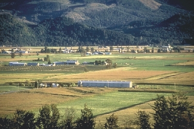
Ice-Age upland near Langley (23-close up, 24-aerial view to the northwest).
This upland is underlain mainly by silty and clayey marine sediments. Soils developed on these sediments are very productive and are one of the reasons the Fraser Valley is an important agricultural area. Only 4% of British Columbia's farmland is in the Fraser Valley, yet this area accounts for over 50% of B.C.'s agricultural income, about $500 million per year.
7. Fraser River
The Fraser River gathers waters and sediment from nearly one-quarter of British Columbia. As the river leaves the narrow confines of the Fraser Canyon at Hope, it spreads out, loses energy, and drops the coarsest of its sediment load. Deposits of coarse sand and gravel form numerous islands in the river between Hope and Mission. At Mission, the gradient of the river decreases, and the flow can carry only sand, silt, and clay. West of Mission, the Fraser River flows in a single channel with few islands. The river splits into several channels below New Westminster. These channels cross a delta constructed over the last 10,000 years.
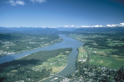
Photo 19 Fraser River near Fort Langley; view upstream from McMillan Island. The river here has a relatively stable, somewhat winding channel with few large islands; it transports only sand, silt, and clay; and its channel is floored with sand. Dykes prevent flooding of the surrounding low-lying floodplain.
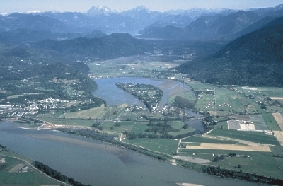
Photo 20 Hatzic Lake, just east of Mission, is a classic example of an oxbow lake. The lake occupies an old meander channel (oxbow) of the Fraser River. Hundreds of years ago, the river abandoned this crescent-shaped channel and began to flow along its present route. Over time, the ends of the oxbow gradually became plugged with Fraser River sediment, creating Hatzic Lake.
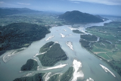
Photo 21 Fraser River near Chilliwack, looking downstream. Islands of gravel and sand within the river can support only fast-growing deciduous trees such as cottonwood because the islands shift and are regularly flooded. Dykes protect communities on the flats north and south of the river from flooding. Sumas and Chilliwack Mountains are bedrock ridges.
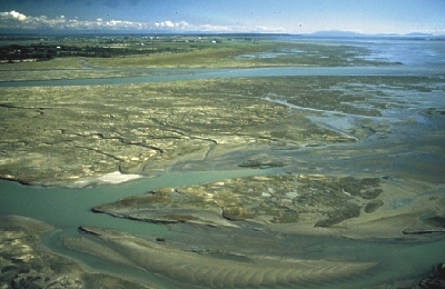
Photo 30 Mouth of the Fraser River; view south from the vicinity of the Vancouver International Airport. The river flows into the Strait of Georgia here, ending its 1400 km odyssey. River-borne sand, silt, and clay are distributed by currents, waves, and the river itself to form an intricate network of tidal flats, islands, and channels.
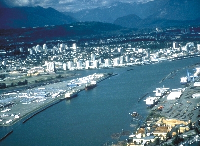
Photo 31 Apex of the Fraser delta at New Westminster. The Fraser River splits here into two distributary channels, the North Arm and Main Channel. This reach of the river is heavily industrialized -- the Main Channel has been deepened by dredging to allow ships access to New Westminster; logs are temporarily stored in booms; and mills and homes crowd the river banks. The Fraser delta, home to 200,000 people, is only 1 to 2 m above mean sea level.
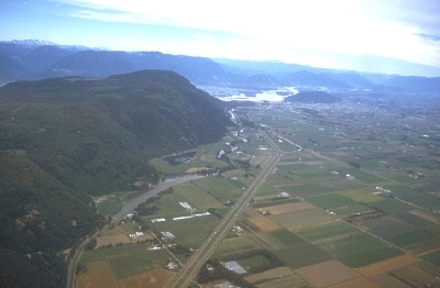
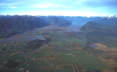
Photo 32 View north across Pitt Meadows to Pitt Lake and the southern Coast Mountains. The floodplain in the foreground formed over the last 5000 years as the Fraser River built a delta northward into Pitt Lake. This process continues today -- the flow of the Pitt River reverses when the level of the Fraser River is high, and sediment moves northward up the Pitt River into Pitt Lake. Pitt Lake occupies a deep, U-shaped valley that was partially excavated by glaciers during the Ice Age.
8. Fraser Delta The Fraser River delta is the largest delta in western Canada. It is also an important coastal wetland ecosystem, as well as an area of explosive urban and industrial growth. The Fraser delta is a thick pile of sands and silts deposited at the mouth of the Fraser River over the last 10,000 years. The delta top is a near-featureless, flat plain crossed by the distributary channels of the Fraser River. Broad tidal flats extend up to 9 km west of the dyked portion of the plain to the delta slope which drops off into deep water of the Strait of Georgia. Tidal flats are also present on the southern flank of the Fraser delta in Boundary Bay.
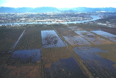
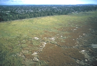
Photo 1 Burns Bog, the largest peat bog in the Lower Mainland, began to develop about 5000 years ago on the flat, poorly drained surface of the Fraser delta. In the past, Burns Bog has been extensively mined for Sphagnum moss which is used as a soil conditioner; this photo shows one of the mined areas. In addition, peatlands on the Fraser delta are among the top three blueberry- and cranberry-producing areas in the world.
Photo 2 Tidal marsh at the front of the Fraser delta; behind the marsh is a sea dyke and the City of Richmond. Fraser delta marshes are a critical stop on an important bird migration route. Hundreds of millions of juvenile salmon also use the marshes and adjacent distributary channels. Large areas of marsh have been lost in the last 100 years due to dyking, dredging, filling, construction, and effluent discharge.
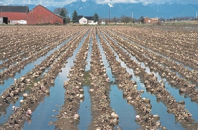
Photo 4 Silty and clayey sediments on the Fraser delta are some of the most productive agricultural soils in British Columbia. A high water table, however, causes water to collect on the surface during much of the year. Over most of the delta, the silts and clays are several metres thick, and overlie sands deposited thousands of years ago in former channels of the Fraser River.
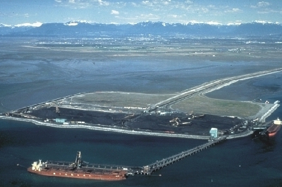
Photo 5 Vancouver Deltaport, Canada's largest coal export facility, was built on fill placed on the tidal flats northwest of Tsawwassen. The Deltaport is one of a number of important engineered structures at the delta front (ferry terminal, river training walls, sewage outfall). The structures have changed the tidal flat environment by altering how sediment disperses at the delta front.
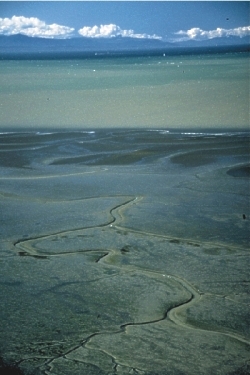
Photo 6 The western front of the Fraser delta; view west to the Strait of Georgia. A marsh, cut by a meandering tidal channel, is bordered seaward by unvegetated tidal flats. Offshore, muddy Fraser River water contrasts with blue water of the Strait of Georgia.
9. Shorelines
Some shores in the Vancouver area are bedrock, some are man-made fill, others are tidal marshes, and still others are beaches of sand and gravel. Coastal bluffs developed in Ice Age deposits are vulnerable to wave erosion and landslides; many have retreated significantly in this century. Sediment eroded from the bluffs is carried by currents along the shore and deposited on beaches.
Photo 3 Intertidal sand flat in Boundary Bay; view southwest towards Point Roberts at a low tide. Much of this sand was eroded by waves from sea cliffs of Ice Age sediments at Point Roberts and carried northward by currents into Boundary Bay. Currents and tides have molded the sand into broad, low dunes oriented parallel to the shoreline.
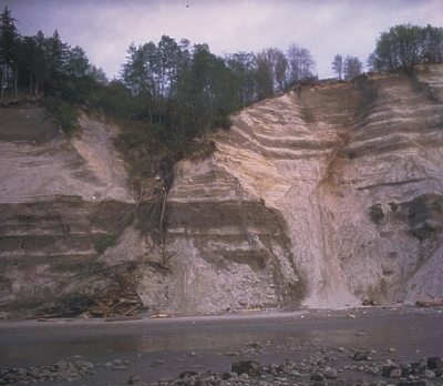
Photo 7 Point Grey sea cliff; photo taken in the late 1970s. The cliff's loose Ice Age sediments are eroded by waves and groundwater. The shore has retreated inland up to several tens of metres in the last 50 years, threatening some buildings at the top of the cliff. An erosion control program, implemented in 1981, has significantly slowed the retreat.
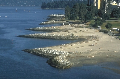
Photo 8 Groins along Vancouver's English Bay shoreline trap sand and reduce beach erosion. Without the groins, currents and waves would strip sand from the beach. This shoreline is visible in photo 14.


