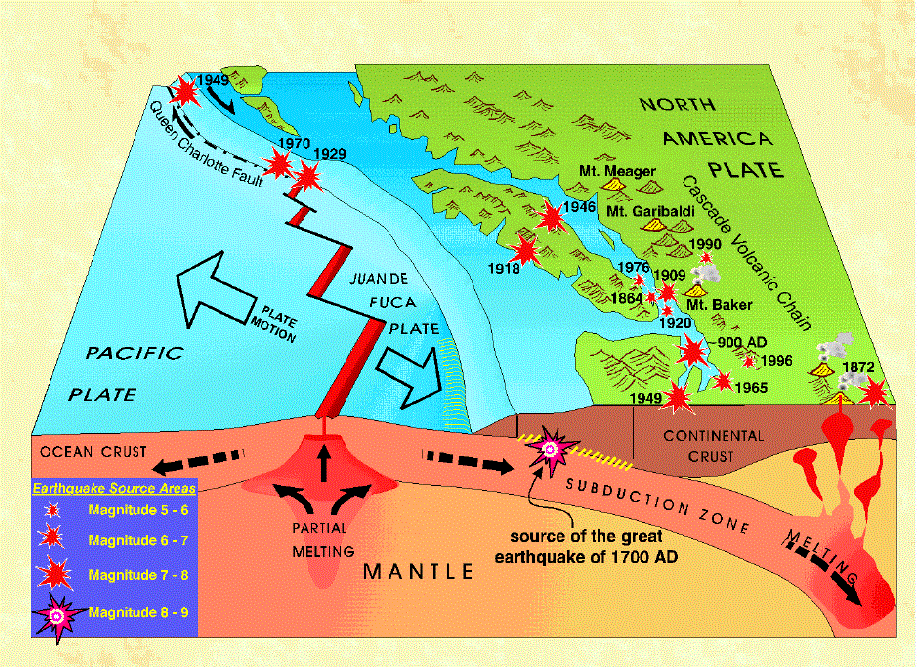
An earthquake is the result of a sudden release of energy when rocks under stress slide abruptly past one another along a break in the Earth's crust (fault). Most earthquakes occur where the large rigid plates that make up the outer shell of the Earth are in contact with one another.
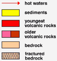
Block diagram of southwest B.C. showing the Juan de Fuca plate descending beneath North America along a subduction zone.
Where Earthquakes Happen
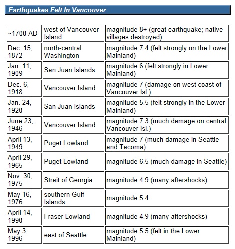
There is an average of one earthquake in southwest B.C. every day. Nearly all are too small to be felt, but a damaging earthquake occurs somewhere in the region about once every 20 years. The largest earthquake in this century was a magnitude 7.3 event in 1946, centred beneath central Vancouver Island. Were this earthquake to occur today under Vancouver, damage would be in the billions of dollars. Recently, scientists have recognized a history of infrequent, but great (magnitude 8 to 9) earthquakes on the fault separating the subducting Juan de Fuca and North America plates. The last great earthquake in 1700 AD affected the entire coast from northern California to southern B.C.
Quake Damage
The effect of an earthquake includes ground shaking, landslides, and liquefaction (change of sediment from a solid to a quicksand-like liquid state). Earthquakes are most destructive when they are centered near cities, but the damage can differ considerably from site to site because of local geological conditions. For example, shaking on loose sediment is likely to be greater than shaking on bedrock. Some earthquakes trigger destructive sea waves (tsunamis) that can surge hundreds of metres inland, have heights of 10 m or more, and cause loss of life and severe property damage. In southwest B.C., the tsunami threat is greatest on the outer coast of Vancouver Island.
Earthquakes cannot be prevented. However, the damage they cause can be reduced through geological and geophysical studies that contribute to proper design of buildings and other structures, emergency planning, and public education. Geological mapping can identify areas of possible severe ground shaking, liquefaction, or landslides.
What's under our feet?
A simplified geological map of the Vancouver area, showing the distribution of different earth materials at the surface.
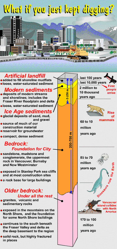
Some areas covered with modern sediments are more susceptible to flooding and to damage during an earthquake than areas of compacted Ice Age sediments or bedrock. Much vital infrastructure has been built on these hazard-prone modern sediments.
The earth materials you would encounter if you just kept digging in downtown Vancouver.