CGEN Archive

Geoscape - Vancouver

CGEN's Home Page
  • Home
  • CGEN Minutes
  • EarthLinks
  • EdGEO
    • Bringing Earth Science to Life
    • Putting the Earth into Science
  • FBY
    • FBY-Chapter Previews
    • FBY-Sample Lesson
    • QMA-Apercus des chapitres
  • Geoscape
    • Geoscape Canada >
      • Calgary
      • Fort Fraser
      • Montreal
      • Nanaimo
      • Northwest Territories
      • Ottawa-Gatineau
      • Québec
      • Saskatchewan-North
      • Saskatchewan-South
      • Toronto
      • Vancouver
      • Victoria
      • Whitehorse
    • Géopanorama du Canada
    • Geoscape Posters
    • Geotours
    • Waterscapes >
      • Bowen Island
      • Bow River Basin
      • Gulf Islands
      • Okanagan Basin
  • Geovistas
  • Key Publications
    • Wat On Earth
  • OGGP
  • Contact Us
Geoscape - Vancouver
  • Home
  • In the Shadow of Volcanoes
  • Sea to Sky
  • The Fraser River Delta
  • Earthquake!!
  • Earth Resources
  • Mountain Corridors
  • Water Underground
  • When the Fraser Floods
  • Mountain Watersheds 
  • Credits & Citation
  • Poster Downloads
And...
  • Aerial Landscapes
  • Geomap Vancouver
  • Vancouver's Landscape
  • Vancouver Rocks

Geoscape - Vancouver

  • Water Underground

Vital But Vulnerable

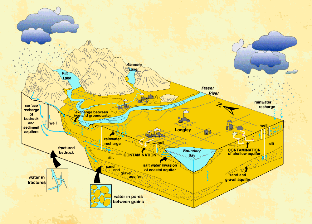
Groundwater is a hidden, often forgotten resource, yet it meets about half of the total water needs of areas not served by the North Shore reservoirs. Groundwater is supplied from over 10 000 wells in the Fraser Valley. Most of these are small household wells, but some high-yield wells support large communities and industries. Groundwater quality in many areas has been degraded by fertilizers, pesticides, septic field effluent, farm animal waste, and industrial chemicals. This carelessness results, perhaps, from the attitude "out of sight, out of mind".

Groundwater in the Vancouver area occurs in two main types of materials - modern and Ice Age sands and gravels, and fractured bedrock. The water is stored in pores between grains in sediments and in fractures in bedrock.
Picture
Géopanorama du Canada
Geoscapes:
  • Canada
  • Calgary
  • Fort Fraser
  • Montreal
  • Nanaimo
  • Northwest Territories
  • Ottawa-Gatineau
  • Québec
  • Saskatchewan - North
  • Saskatchewan - South
  • Toronto
  • Vancouver
  • Victoria
  • Whitehorse
Copyright CGEN 2014-2021
​ Quick Links to Earth Sciences Canada sites
​Earthlinks | WHERE Challenge | Careers in Earth Science |  Four Billion Years and Counting | IYPE | CFES | CGEN | IUGS | GeoVistas | OGGP