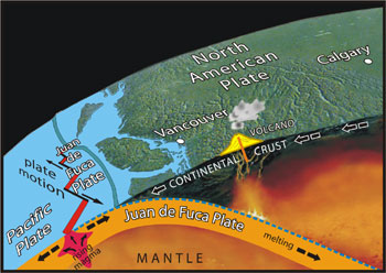
Calgary is located in a geologically stable setting, 800 km inland from active faults and volcanoes. The faults are related to the subduction of the Juan de Fuca Plate under the continental crust of North America and are a major source of earthquakes on the West Coast. As the oceanic crust on the plate descends, it melts and gives rise to some of the volcanoes in the west.
Subduction of oceanic crust beneath Canada's West Coast (Source: B. Groulx, T. Poulton)
Just a Little Bit Shaky
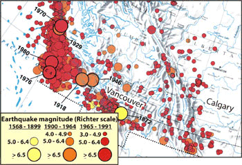
Despite Calgary's location far from active faults, some small earthquakes have occurred in the region. Some of these result from the minor jostling and adjustments related to movement of geological plates. Others are caused by stresses in the rocks associated with removal of oil and gas from underground reservoirs, an effect taken into account by the industry.
Low density of epicentres near Calgary
(Source: Canada seismicity, National Atlas of Canada, 5th edition)
The earthquake epicentre map shows the location, magnitude, and timing of earthquakes in historical times. Note the greater density and higher magnitude of earthquakes on the coast.
A Blast From the Past
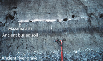
Mazama ash layer exposed along Fish Creek in Calgary (Photograph by G. Osborn)
Although Calgary is a long way from active volcanoes, many residents will remember the dusting of volcanic ash from the eruption of Mount St. Helens in 1980.
A much larger eruption occurred 7700 years ago, when Mount Mazama in southern Oregon erupted with such violence that much of the mountain was removed, creating the depression now occupied by Crater Lake. The eruption was so large that volcanic ash reached as far as Calgary and Edmonton. A layer of Mazama ash can be seen today in many places in southern Alberta and British Columbia.