CGEN Archive

Geoscape - Calgary

CGEN's Home Page
  • Home
  • CGEN Newsletter
    • CGEN Minutes
  • EarthLinks
  • EdGEO
    • Bringing Earth Science to Life
    • Putting the Earth into Science
  • FBY
    • FBY-Chapter Previews
    • FBY-Sample Lesson
    • QMA-Apercus des chapitres
  • Geoscape
    • Geoscape Canada >
      • Calgary
      • Fort Fraser
      • Montreal
      • Nanaimo
      • Northwest Territories
      • Ottawa-Gatineau
      • Québec
      • Saskatchewan-North
      • Saskatchewan-South
      • Toronto
      • Vancouver
      • Victoria
      • Whitehorse
    • Géopanorama du Canada
    • Geoscape Posters
    • Geotours
    • Waterscapes >
      • Bowen Island
      • Bow River Basin
      • Gulf Islands
      • Okanagan Basin
  • Geovistas
  • Key Publications
    • Wat On Earth
  • OGGP
  • Contact Us
Geoscape - Calgary
  • Home
  • Introduction
  • Landscapes
  • Stable Crust
  • Glacial History
  • Rock Resources
  • Sandstone City
  • Fossil Fuel Energy
  • Slope Stability
  • Rivers...Friend and Foe
  • Groundwater
  • Virtual Tours
  • Credits & Citation
  • Poster Downloads

Geoscape - Calgary

Sandstone City

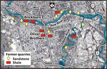
On November 7, 1886, a devastating fire destroyed many wooden buildings on the main street of Calgary. To avoid another catastrophe, Calgarians decided to rebuild the town with Paskapoo Sandstone, a more fireproof material. This decision marked the beginning of the 'sandstone era', during which 15 quarries operated in and around Calgary. Sandstone was used to build schools, churches, and large private and public buildings, including the old part of City Hall, built in 1911 (800 Macleod Trail SE).
Picture
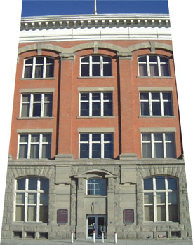
The old Customs Building (134-11 Avenue SE) was built with Paskapoo Sandstone from an Oliver Brothers quarry (grey blocks) and Brickburn brick (Photo: B. Groulx)
Sandstone

Paskapoo Sandstone consists of sand grains eroded from the ancestral Rocky Mountains and transported to the east by rivers 65 to 58 million years ago. Over time, the sands were buried under hundreds of metres of younger sediment, cemented with minerals precipitated from groundwater, and then slowly exposed by erosion to form the sandstone outcrops that can be seen today along our river valleys.
Picture
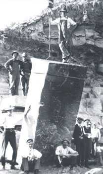
Stonecutters and a block of Paskapoo Sandstone in a quarry near Calgary (Photo: courtesy Glenbow Museum)
The Brick Boom

The 1886 fire also sparked a brick industry in Calgary. People began to build chimneys out of fireproof brick made from shale that is interlayered with Paskapoo Sandstone. From 1907 until 1912, brick homes were in vogue and the Calgary brickyards boomed. In 1914, however, the First World War brought an end to both industries as employees left to serve in the armed forces.
Picture
Former quarry locations in Calgary
Géopanorama du Canada
Geoscapes:
  • Canada
  • Calgary
  • Fort Fraser
  • Montreal
  • Nanaimo
  • Northwest Territories
  • Ottawa-Gatineau
  • Québec
  • Saskatchewan - North
  • Saskatchewan - South
  • Toronto
  • Vancouver
  • Victoria
  • Whitehorse

Copyright CGEN 2014-2020
​ Quick Links to Earth Sciences Canada sites
​Earthlinks | WHERE Challenge | Careers in Earth Science |  Four Billion Years and Counting | IYPE | CFES | CGEN | IUGS | GeoVistas | OGGP