View of Calgary's downtown core looking west from the Elbow River escarpment, showing intensive development on the floodplains in both the Bow and Elbow river valleys
No significant flood has occurred in Calgary since 1932 and, consequently, very few people consider flooding to be a major hazard. As a result of this lull in flood activity and of the attractiveness of living near Calgary's waterways, development in Calgary's river valleys has increased dramatically since 1932.
Dikes along the riverbanks within the city and dams along the Bow River upstream from the city will control much floodwater in the case of heavy flows. However, if another 100-year flood (a flood of such size that it has 1 chance in 100 of occurring in any given year), such as the flood of 1897, were to occur today, the Bow River would see its normal flow rate rise from 92.9 m3/s to 2265 m3/s, more than 24 times its normal volume. The potential damage has been estimated at $131 million in 1996 dollars.
Estimates of flood damages are calculated by considering water velocity and flood extent. As obstructions such as houses and other man-made obstacles decrease water velocity, the height and width of the floodwaters increase. Given that development in our river valleys has increased dramatically since 1932, the extent of flood damages would be exponentially much higher if another 100-year flood were to occur today.
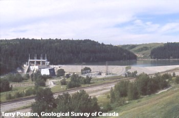
Stop 2 - Bearspaw Dam
Bearspaw dam, constructed in 1954, is the first of three dams along the Bow River west of Calgary
This dam was built at the same time as dikes in the central part of the city for the main purpose of controlling winter ice-jam floods, which occurred most frequently during the 1950s. Winter ice-jam floods can occur at any time during the winter when Chinook winds partially melt the surface ice, which subsequently breaks up and piles up against bridge abutments in the river. Since the construction of the Bearspaw dam and dikes through the central part of the city, this type of flooding has largely been controlled (Alberta Environment, 1996). However, because of the dam's small capacity, the threat of further winter flooding should not be overlooked. In 1966, 11 years after the dam's construction, dikes protecting Sunnyside were filled to the brim and Calgary narrowly avoided flooding.
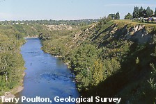
Stop 3 - Elbow River and Glenmore Dam
View towards the Glenmore Dam, overlooking Stanley Park in the Elbow River valley
The Glenmore dam was constructed in 1932 with the dual purpose of providing drinking water to Calgary's expanding population and flood protection to those living in the river valleys. In 1932, shortly after the Glenmore Dam had been constructed and even though the reservoir sat empty at the time, water flowed over the top and severe flooding was recorded downstream.
View looking down the Elbow River from the top of the Glenmore dam
As the Elbow River winds its way through Calgary, it cuts steep cliffs into the loose, fine-grained sediment deposited by glaciers and glacial lakes 10 000 to 25 000 years ago and through the Early Tertiary sandstone bedrock underlying the glacial deposits. Today, because of their steep and unconsolidated nature, many of these slopes are unstable and pose a risk to housing developments placed too close to them. Seven of Calgary's more significant landslides have been caused by human activity. A main influence is excessive lawn watering at homes that were placed too close to the cliffs at the river edge.
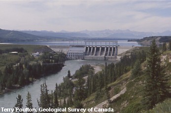
Stop 4 - Ghost Dam
View looking west over the Ghost dam
The Ghost dam today is an increasingly popular recreational area for boaters and fishermen in Calgary and provides valuable hydroelectric power to the region.
Many believe that dams on the Bow River such as this one and the one at Seebe have effectively controlled flooding in Calgary. However, these dams are too far upstream to control the majority of the drainage basin and too small to control the amount of water produced by very high spring or summer runoff, say from a 100-year flood. In addition, these reservoirs are commonly full during times of highest flood risk. In the flood of 1932, the newly built Glenmore reservoir overflowed, even though it had been empty before the flood.
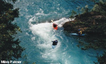
Stop 5 - Kananaskis River Below Barrier Dam
Kayaking at 'Hollywood Hole' along the Kananaskis River
The Kananaskis, Bow, and Elbow rivers play an important role in Calgary's tourist and recreation industry, providing a natural retreat within our backyard that attracts world-class athletes and fishermen from around the world. Although most Calgarians appreciate the rivers for these qualities, few are aware of their potentially destructive forces.
Of all the rivers in the Calgary area, the Kananaskis is the most heavily controlled by hydroelectric dams throughout its watershed.
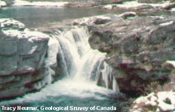
Stop 6 - Elbow Falls
Seen in its calmest state in late fall, the Elbow River at Elbow Falls is a beautiful site.
The Elbow River begins its journey near the top of the Highwood Pass at Elbow Lake in Peter Lougheed Provincial Park. From there, it makes its way down through the limestone canyons of the Front Ranges and Foothills, passing through the small town of Bragg Creek before entering the Glenmore Reservoir in Calgary. Because of a lack of glaciers in the Elbow River valley, recharge of the river relies on annual winter snowfall. Soils in the watershed of the Elbow River near its headwaters lack the absorbing power of many old-growth soils, so the Elbow River is particularly susceptible to flash flooding during intense thunderstorms.
Some of the most noteworthy floods occurred in the 1920s and 1930s when the Elbow River's discharge rate rose from an average of 30 m3/s to over 300 m3/s, over 10 times its normal discharge.
Stop 7 - Bow River Valley
Overlooking the beautiful Bow River valley near Canmore
The Bow River begins its journey at Bow Lake, high on top of Bow Summit (2035 m), as a catchment basin for meltwater flowing out of Bow Glacier along the Wapta Icefield. Because meltwater from many glaciers flows into the Bow River and because of the river's large drainage area, the Bow River can be counted on to supply water to Calgarians during all but the most severe droughts.
With the exception of areas of human habitation, flooding along the Bow River is a beneficial process for many species and is an integral part of maintaining riparian habitats. Species such as the balsam poplar require annual flooding to germinate new seedlings each year and, in many cases, they are most successful after a 100-year flood (because seedlings are high enough away from the river to avoid being swept away by winter ice flows, but are still able to tap into the river's groundwater supply).