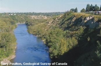
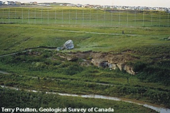
As the Elbow River winds its way through Calgary, it cuts steep cliffs into the loose, fine-grained sediment provided by glaciers and glacial lakes 10 000 to 25 000 years ago. Today, because of their steep and unconsolidated nature, many of these slopes are unstable and pose a risk to housing developments placed too close to them. Some of Calgary's more significant landslides have been caused by human activity, such as excessive lawn watering too close to the cliffs at the top, or excavation of the 'toe' of the slope at the bottom.
Elbow River Escarpment
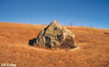
Stop 2 - Nose Hill Park Erratic
This boulder, like the famous "Big Rock" near the town of Okotoks, is one of many quartzite boulders that originated back in the Main Ranges of the Canadian Rockies and were transported to the prairies by Cordilleran valley glaciers 17 000 to 20 000 years ago.
From the rock's composition, geologists have determined that this erratic at Nose Hill came from Mount Edith Cavell near Jasper, Alberta, probably as a result of a landslide that fell onto a valley glacier that followed the Athabasca River valley out onto the Plains, where it was deflected southward by contact with the Laurentide Ice Sheet advancing from the northeast.
Nose Hill Park Erratic
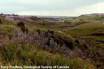
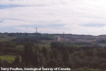
Stop 3a - Nose Creek
Nose Creek today is a calm, meandering stream that winds its way down a peaceful valley in northwest Calgary and is a popular green space for Calgary's growing population. The creek is clearly much smaller than the valley it occupies (a 'misfit' stream) and was not capable of eroding a valley of this size. The current that created the valley now confining Nose Creek was in force back at the end of the last ice age, when large quantities of meltwater spewed out from retreating ice sheets, at times completely filling up this valley.
The valley that confines Nose Creek is termed a 'glacial outwash channel', a relic of a climate long ago. Other examples of ancient outwash channels in the Calgary area include the Fish Creek valley, the Nose Creek valley from 17th Avenue north to Airdrie, and the Big Hill Creek valley that houses the Cochrane Ranche Provincial Historic Site.
View down Nose Creek in NW Calgary
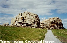
Stop 3b W. Nose Creek
The large rock ('Split Rock') that rests on top of the small cliff above West Nose Creek is a glacial erratic that began its journey east on a large valley glacier from a valley near Jasper 17 000 to 20 000 years ago. Today, many erratics like this one, including the famous 'Big Rock' near Okotoks, form part of an erratic train that extends from Jasper all the way south to the Montana-Alberta border. This erratic train represents a line where ice flowing from the east and ice from the western mountains met to form a medial moraine.
The small cliff at the edge of the creek is an outcrop of Paskapoo Formation sandstone, which dates back to the Early Tertiary (Paleocene). This cliff was excavated as a potential sandstone quarry, one of many quarries from which Calgarians acquired the sandstone blocks used to construct many of the older heritage buildings that still exist in the downtown area.
Quartzite erratic on top of a sandstone quarry in W. Nose Creek
Stop 4 - Bearspaw
This beautiful area of rolling hills and small lakes is one of the many end moraines created as a result of the stagnation (melting) of the great Laurentide Ice Sheet near the end of the Quaternary, 10 000 to 17 000 years ago.
The many hills and small lakes present were formed by a process whereby ice melts at different rates because of the thickness of the debris (insulation) covering the ice. If a layer of debris is thick enough, it will prevent solar radiation from reaching the ice, thus insulating it from further melting. On the other hand, if the debris cover is thin enough, then it will absorb solar radiation and melt the surrounding ice much faster than ice would normally melt on its own. As the ice in this area continued to melt at different rates, the rock and debris that insulated parts of the ice washed into the depressions produced by the faster melting ice. Once the ice had finally melted away, the debris that once insulated it formed the many rolling hills and the ice insulated by the debris formed the beautiful small lakes.
Knob-and-kettle topography, or 'hummocky terrain', seen here near Bearspaw along Highway 1A west of Calgary
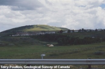
Stop 5 - Cochrane and Big Spring Coulee
About 10 000 years ago, the valley of Big Hill Creek carried a lot more water than it does today. At that time, this spot was actually an old delta created as meltwater travelling through the valley entered Glacial Lake Calgary. This delta indicates the water level of the ancient glacial lake. Today's Big Hill Creek has cut through the edge of the delta before passing under Highway 1A.
Delta at Big Spring Coulee. View to the right, looking toward the Cochrane Ranche Provincial Historic Site and the Big Hill Creek valley
Stop 6 - Morely Flats
Drumlins were formed when glaciers deposited rock and clay debris in the lee of obstructions on the land surface under them. The blunt, steep ends point in the direction from which the ice flowed (upstream) and the gentle, tapered ends point downstream.
Morely Drumlins. Drumlins are a common sight at Morley Flats beside Highway 1, 42 km west of Calgary.
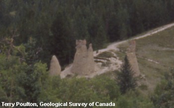
Stop 7 - Hoodoos at Canmore
Hoodoos in the Bow River valley most commonly occur in the thick glacial till exposed low in the valley walls, usually along steep river valleys and cliffs, where the till is exposed to water and wind erosion. These till pillars erode more quickly if they are disturbed by tourists climbing on them.
Canmore Hoodoos. These hoodoos are located on the northeast side of Highway 1 in Canmore.
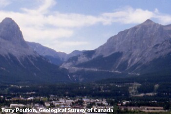
Stop 8 - Canmore
Whiteman's Gap, above the town of Canmore, with its beautiful cascading waterfalls, is a classic example of a hanging valley and serves as the entrance to the beautiful Spray River valley. Today the vertical drop from the Spray River valley to the Bow River valley is used to generate hydroelectric power using water from the Spray Lakes Reservoir.
The classic U-shaped valley at Whiteman's Gap was created by glaciers as they eroded the valleys in the Canadian Rockies during the last ice age. It is a 'hanging valley', that is suspended above the larger Bow River valley, which was also eroded by glaciers into a U-shaped profile.
Whitemans Gap above the town of Canmore
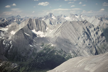
Stop 9 - Alpine Cirque Bowls
Cirque bowls found high in the alpine region represent the type of classic Rocky Mountain scenery that Calgarians have come to love and enjoy. Cirque bowls are an erosional feature created by cirque glaciers and are usually found at elevations above 2000 m. They are often occupied by small lakes ('tarns'). Most cirque glaciers in the Canadian Rockies are oriented toward the northeast, as that is the direction that receives the least sunlight and the most leeward snow deposition from our strong southwest winds.
Classic cirque bowls high in the alpine as seen from the top of the Three Sisters in the Spray Valley. (Photo: Margot McMechan)
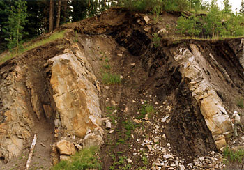
Stop 10 - Mesozoic Sandstone
Mesozoic (Cretaceous) sandstone seen here thrust to the surface in the Foothills along Highway 1 west of Calgary is the source of much of Alberta's oil and natural gas.
Learn more about Alberta's tropical past and how our fossil fuels were formed
Mesozoic sandstone shown thrust to the surface in the Foothills along Highway 1 west of Calgary (Photo: A. Sweet)
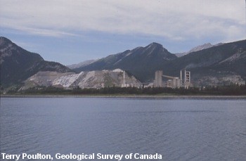
Stop 11 - Lac des Arcs
Calgarians are fortunate to have an abundant supply of aggregate nearby, to use for construction and road materials. Many other cities have to import aggregate from great distances. At Lac des Arcs (Gap Lake), limestone is quarried and mixed with sandstone and shale, then ground, burned in kilns, and treated with gypsum to form cement.
Limestone quarry along Highway 1 west of Calgary at Lac des Arcs
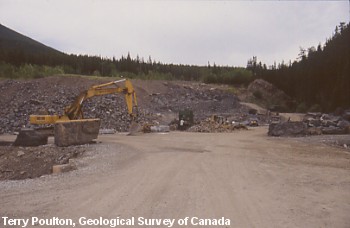
Stop 12 - Pigeon Mountain Rundle Rock Quarry
Rundle Rock, known for its smooth surfaces and blocky shapes, is the famous building stone used for the Banff Springs Hotel and a popular decorative stone in and around Calgary. It was first described in 1887 by geologist R.G. McConnell and was named by stone masons quarrying the rock from the base of Mount Rundle near the town of Banff. Rundle Rock is a blocky sandstone with earthy grey and brown colours that originated as sand deposited on Early Mesozoic seafloors about 245 million years ago.
Rundle Rock quarry at base of Pigeon Mountain
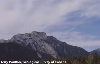
Stop 13 - Heart Mountain
Heart Mountain, formed entirely of Paleozoic limestone, is an example of the limestone-rich mountains of the Rocky Mountains Front Ranges. Heart Mountain is interesting because of the synclines and anticlines with many distinctive chevron folds that can be seen on either side of it.
Learn more about how folds and faults play an important role in locating and extracting fossil fuels.
Heart Mountain, named after the heart-like shape formed by the rocks at its peak
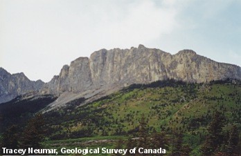
Stop 14 - Mount Yamnuska
Mount Yamnuska is an example of a Front Ranges mountain that consists of older (Paleozoic) formations thrust tens of kilometres from the west to lie on top of younger (Mesozoic) rock. This relationship was created by the McConnell Thrust Fault, which can be seen today where the Paleozoic limestone cliff meets the treeline and turns into Mesozoic mudstone and sandstone. This major fault contact is so sharp that you can cover it with your finger.
Today Mount Yamnuska is a popular rock-climbing destination, attracting everyone from beginners to the world's best.
Mount Yamnuska, the first major mountain on the north side of highways 1 and 1A, heading west from Calgary