CGEN Archive

Geoscape - S. Saskatchewan

CGEN's Home Page
  • Home
  • CGEN Newsletter
    • CGEN Minutes
  • EarthLinks
  • EdGEO
    • Bringing Earth Science to Life
    • Putting the Earth into Science
  • FBY
    • FBY-Chapter Previews
    • FBY-Sample Lesson
    • QMA-Apercus des chapitres
  • Geoscape
    • Geoscape Canada >
      • Calgary
      • Fort Fraser
      • Montreal
      • Nanaimo
      • Northwest Territories
      • Ottawa-Gatineau
      • Québec
      • Saskatchewan-North
      • Saskatchewan-South
      • Toronto
      • Vancouver
      • Victoria
      • Whitehorse
    • Géopanorama du Canada
    • Geoscape Posters
    • Geotours
    • Waterscapes >
      • Bowen Island
      • Bow River Basin
      • Gulf Islands
      • Okanagan Basin
  • Geovistas
  • Key Publications
    • Wat On Earth
  • OGGP
  • Contact Us
Geoscape - Southern Saskatchewan
  • Home
  • Our Landscape
  • Big Valleys
  • Food From the Land
  • Badlands and Dinosaurs
  • Keep digging?
  • Water
  • Groundwater
  • Heaves and Cracks
  • Earth Resources
  • Landslides
  • Credits & Citation
  • Poster Downloads

Geoscape - S. Saskatchewan

Our Landscape

Picture
Our Diverse Prairie Landscape: 
Saskatchewan is not just flat!

[PDF, 475.5 kb]

The Ice Age: Architect of Our Landscape

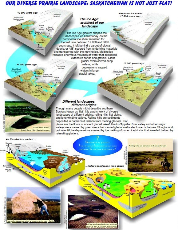
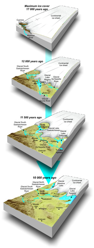
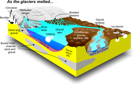
The Ice Age glaciers shaped the landscapes we know today. As the continental ice sheet retreated for the last time between 17,000 and 8,000 years ago, it left behind a carpet of glacial debris, or 'till', scoured from underlying materials and transported with the moving ice. Melting ice released enormous volumes of water that deposited extensive sands and gravels. Giant glacial rivers carved deep valleys, while depressions trapped waters in large glacial lakes.
Picture

Ice Cover (Top to Bottom)
  • Maximum  - 17 000 years ago
  • 12 000 years ago
  • 11 500 years ago
  • 10 000 years ago


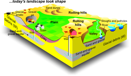
Different Landscapes, Different Origins

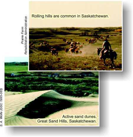
Though many people might describe southern Saskatchewan as 'flat', it is a patchwork of diverse landscapes of different origins: rolling hills, flat plains, and long winding valleys. Rolling hills are sediments deposited in haphazard fashion from melting glaciers. Flat plains are the floors of ancient glacial lakes! 

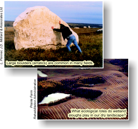
The Qu'Appelle River valley and other major valleys were carved by great rivers that carried glacial meltwater towards the sea. Sloughs and potholes fill the depressions created by the melting of buried ice blocks that were left behind by retreating glaciers.

Picture
Picture
Picture


  • Rolling hills are common in Saskatchewan.


  • Active sand dunes, Great Sand Hills, Saskatchewan.
Picture

  • Large boulders (erratics) are common in many fields.


  • What ecological roles do wetland sloughs play in our dry landscape?


Untouched by Glaciers

A small part of Saskatchewan was never glaciated. Do you know where this is?
Géopanorama du Canada
Geoscapes:
  • Canada
  • Calgary
  • Fort Fraser
  • Montreal
  • Nanaimo
  • Northwest Territories
  • Ottawa-Gatineau
  • Québec
  • Saskatchewan - North
  • Saskatchewan - South
  • Toronto
  • Vancouver
  • Victoria
  • Whitehorse
Copyright CGEN 2014-2020
​ Quick Links to Earth Sciences Canada sites
​Earthlinks | WHERE Challenge | Careers in Earth Science |  Four Billion Years and Counting | IYPE | CFES | CGEN | IUGS | GeoVistas | OGGP