CGEN Archive

Geoscape - S. Saskatchewan

CGEN's Home Page
  • Home
  • CGEN Minutes
  • EarthLinks
  • EdGEO
    • Bringing Earth Science to Life
    • Putting the Earth into Science
  • FBY
    • FBY-Chapter Previews
    • FBY-Sample Lesson
    • QMA-Apercus des chapitres
  • Geoscape
    • Geoscape Canada >
      • Calgary
      • Fort Fraser
      • Montreal
      • Nanaimo
      • Northwest Territories
      • Ottawa-Gatineau
      • Québec
      • Saskatchewan-North
      • Saskatchewan-South
      • Toronto
      • Vancouver
      • Victoria
      • Whitehorse
    • Géopanorama du Canada
    • Geoscape Posters
    • Geotours
    • Waterscapes >
      • Bowen Island
      • Bow River Basin
      • Gulf Islands
      • Okanagan Basin
  • Geovistas
  • Key Publications
    • Wat On Earth
  • OGGP
  • Contact Us
Geoscape - Southern Saskatchewan
  • Home
  • Our Landscape
  • Big Valleys
  • Food From the Land
  • Badlands and Dinosaurs
  • Keep digging?
  • Water
  • Groundwater
  • Heaves and Cracks
  • Earth Resources
  • Landslides
  • Credits & Citation
  • Poster Downloads

Geoscape - S. Saskatchewan

Groundwater

Picture
Groundwater: Vital But Vulnerable
[PDF, 317.7 kb]

Tapping Subterranean Water

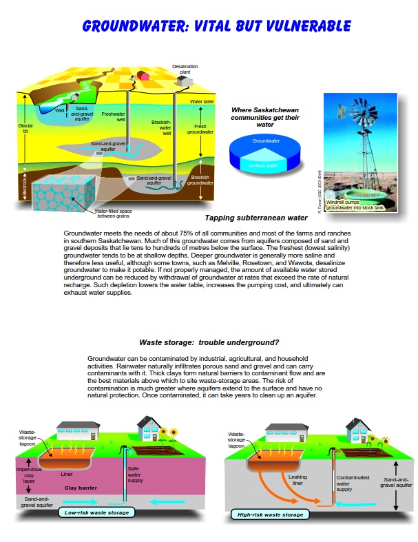
Groundwater meets the needs of about 75% of all communities and most of the farms and ranches in southern Saskatchewan. Much of this groundwater comes from aquifers composed of sand and gravel deposits that lie tens to hundreds of metres below the surface. The freshest (lowest salinity) groundwater tends to be at shallow depths. Deeper groundwater is generally more saline and therefore less useful, although some towns, such as Melville, Rosetown, and Wawota, desalinize groundwater to make it potable. 

If not properly managed, the amount of available water stored underground can be reduced by withdrawal of groundwater at rates that exceed the rate of natural recharge. Such depletion lowers the water table, increases the pumping cost, and ultimately can exhaust water supplies.

Picture
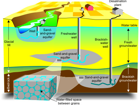
Communities get most of their water from groundwater, windmills pump groundwater in some areas.
Picture

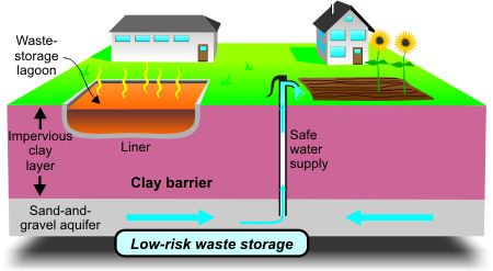
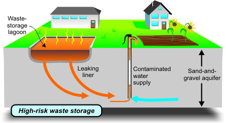
Waste Storage: Trouble Underground?

Groundwater can be contaminated by industrial, agricultural, and household activities. Rainwater naturally infiltrates porous sand and gravel and can carry contaminants with it. Thick clays form natural barriers to contaminant flow and are the best materials above which to site waste-storage areas. The risk of contamination is much greater where aquifers extend to the surface and have no natural protection. Once contaminated, it can take years to clean up an aquifer.
Picture
Low-risk waste storage
Picture
High-risk waste storage
Géopanorama du Canada
Geoscapes:
  • Canada
  • Calgary
  • Fort Fraser
  • Montreal
  • Nanaimo
  • Northwest Territories
  • Ottawa-Gatineau
  • Québec
  • Saskatchewan - North
  • Saskatchewan - South
  • Toronto
  • Vancouver
  • Victoria
  • Whitehorse
Copyright CGEN 2014-2021
​ Quick Links to Earth Sciences Canada sites
​Earthlinks | WHERE Challenge | Careers in Earth Science |  Four Billion Years and Counting | IYPE | CFES | CGEN | IUGS | GeoVistas | OGGP