CGEN Archive

Geoscape - Whitehorse

CGEN's Home Page
  • Home
  • CGEN Newsletter
    • CGEN Minutes
  • EarthLinks
  • EdGEO
    • Bringing Earth Science to Life
    • Putting the Earth into Science
  • FBY
    • FBY-Chapter Previews
    • FBY-Sample Lesson
    • QMA-Apercus des chapitres
  • Geoscape
    • Geoscape Canada >
      • Calgary
      • Fort Fraser
      • Montreal
      • Nanaimo
      • Northwest Territories
      • Ottawa-Gatineau
      • Québec
      • Saskatchewan-North
      • Saskatchewan-South
      • Toronto
      • Vancouver
      • Victoria
      • Whitehorse
    • Géopanorama du Canada
    • Geoscape Posters
    • Geotours
    • Waterscapes >
      • Bowen Island
      • Bow River Basin
      • Gulf Islands
      • Okanagan Basin
  • Geovistas
  • Key Publications
    • Wat On Earth
  • OGGP
  • Contact Us
Geoscape - Whitehorse
  • Home
  • Yukon River
  • Glaciers and Streams
  • Volcanic Eruptions
  • Yukon Time
  • Copper
  • Water and Waste
  • Groundwater
  • Radon Gas
  • Credits & Citation
  • Poster Downloads

Geoscape - Whitehorse

Water and Waste: 
Where it all comes from, where it goes

Drawing from River and Well

The water used to supply Whitehorse comes mostly from Schwatka Lake, a reservoir created by the hydroelectric dam on the Yukon River.  In winter, the cold (0-1°C) lake water is mixed with warmer (4-6°C) groundwater from wells at Riverdale to prevent water lines from freezing. Chlorine is added to kill any bacteria that might be present in the water.
Picture
drawing from river and well
Picture
water cycle

End of the Line -- Treating the Sewage

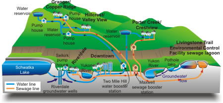
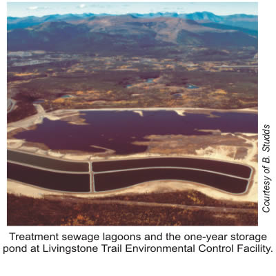
Most of the sewage ends up at the Livingstone Trail Environmental Control Facility. There, solid matter settles to the bottom of the primary lagoon, while effluent flows over into a series of larger secondary lagoons for treatment. Suspended or dissolved matter is then broken down by bacteria. After treatment, the effluent is stored in a large pond for one year. In the fall, when the effluent meets specified treatment standards, it is discharged into the Yukon River. Alternatively, the effluent is discharged to a 'pothole' lake, from which water seeps through soils to the river.

Getting Water to You

Water is pumped from Schwatka Lake to a concrete storage reservoir in each Whitehorse neighbourhood. Each storage reservoir is situated on higher ground than the houses it serves, allowing water to flow by gravity throughout the neighbourhood. 
Picture

Down the drain, and then where?

So where does the water go when we drain our baths or flush our toilets?  Each house has a pipe for incoming drinkable water, and another for outgoing sewage. Household sewage pipes connect to main pipelines that carry sewage downhill by gravity. Where there are low points in the lines, booster stations pump the sewage to the treatment lagoon.
Picture
Géopanorama du Canada
Geoscapes:
  • Canada
  • Calgary
  • Fort Fraser
  • Montreal
  • Nanaimo
  • Northwest Territories
  • Ottawa-Gatineau
  • Québec
  • Saskatchewan - North
  • Saskatchewan - South
  • Toronto
  • Vancouver
  • Victoria
  • Whitehorse
Copyright CGEN 2014-2020
​ Quick Links to Earth Sciences Canada sites
​Earthlinks | WHERE Challenge | Careers in Earth Science |  Four Billion Years and Counting | IYPE | CFES | CGEN | IUGS | GeoVistas | OGGP