CGEN Archive

Geoscape - Whitehorse

CGEN's Home Page
  • Home
  • CGEN Newsletter
    • CGEN Minutes
  • EarthLinks
  • EdGEO
    • Bringing Earth Science to Life
    • Putting the Earth into Science
  • FBY
    • FBY-Chapter Previews
    • FBY-Sample Lesson
    • QMA-Apercus des chapitres
  • Geoscape
    • Geoscape Canada >
      • Calgary
      • Fort Fraser
      • Montreal
      • Nanaimo
      • Northwest Territories
      • Ottawa-Gatineau
      • Québec
      • Saskatchewan-North
      • Saskatchewan-South
      • Toronto
      • Vancouver
      • Victoria
      • Whitehorse
    • Géopanorama du Canada
    • Geoscape Posters
    • Geotours
    • Waterscapes >
      • Bowen Island
      • Bow River Basin
      • Gulf Islands
      • Okanagan Basin
  • Geovistas
  • Key Publications
    • Wat On Earth
  • OGGP
  • Contact Us
Geoscape - Whitehorse
  • Home
  • Yukon River
  • Glaciers and Streams
  • Volcanic Eruptions
  • Yukon Time
  • Copper
  • Water and Waste
  • Groundwater
  • Radon Gas
  • Credits & Citation
  • Poster Downloads

Geoscape - Whitehorse

Yukon Time Began 250 Million Years Ago

Picture
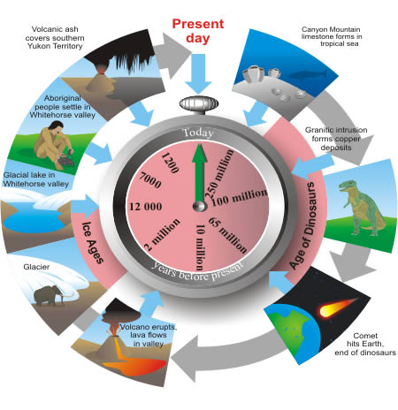
Vast Geological Time, Diverse Geological Materials

The rocks and sediments of the Whitehorse valley have formed through the last 250 million years. They tell remarkable stories about tropical oceans and reefs, granite magmas and copper-rich fluids deep in the Earth, lava flows, violent volcanic ash eruptions, and great glaciations.

An Ancient Tropical Reef

Canyon Mountain (locally known as Grey Mountain) consists of limestone that formed as a reef in a tropical ocean about 250 million years ago. About 170 million years ago, the ocean basin closed, burying and squeezing the reef. Fossils of sponges and other reef animals were destroyed by the pressure and heat. In the recent geological past, water dissolved the limestone, creating crevices and shallow caves.
Picture
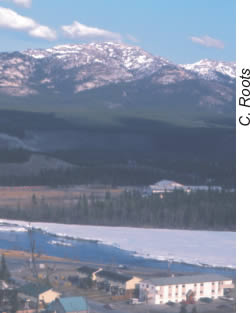
Canyon Mountain, a great mass of limestone, rises southeast of Whitehorse.

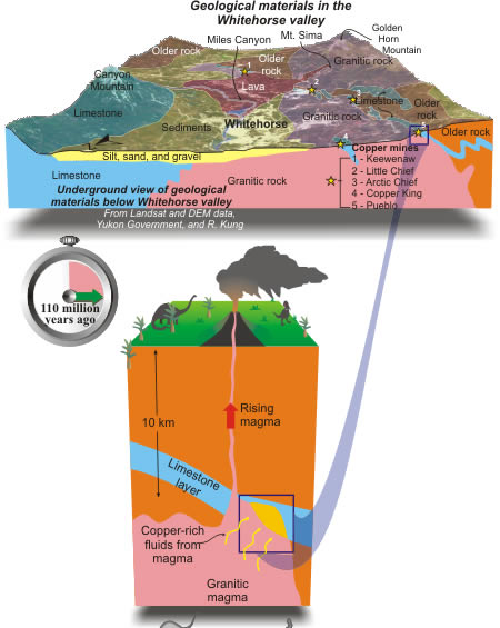
Birth of an Orebody: 
110 million years ago and 10 km down...
Picture
The copper deposits of the Whitehorse Copper Belt occur at the boundary between granite and limestone.  

Why is this so? Geologists explain it this way. The copper deposits formed about 110 million years ago, during the age of dinosaurs. Granitic magma moved upward through deeply buried crustal rocks, including layers of limestone. Copper-bearing fluids released from the crystallizing granite reacted vigorously with limestone, causing copper minerals to precipitate. 

Subsequent erosion of about 10 km of overlying rocks has brought these copper deposits near the surface, where they can be mined.

Géopanorama du Canada
Geoscapes:
  • Canada
  • Calgary
  • Fort Fraser
  • Montreal
  • Nanaimo
  • Northwest Territories
  • Ottawa-Gatineau
  • Québec
  • Saskatchewan - North
  • Saskatchewan - South
  • Toronto
  • Vancouver
  • Victoria
  • Whitehorse
Copyright CGEN 2014-2020
​ Quick Links to Earth Sciences Canada sites
​Earthlinks | WHERE Challenge | Careers in Earth Science |  Four Billion Years and Counting | IYPE | CFES | CGEN | IUGS | GeoVistas | OGGP