Over time the GTA's climate has changed dramatically, encompassing several ice ages or glaciations. Glaciers form when colder climate allows snow to accumulate into thick sheets of ice that flow under their own weight.
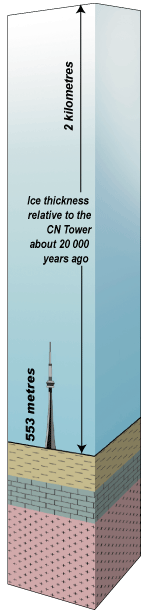
The last advance of the Laurentide Ice Sheet started about 100 000 years ago and extended south into Ohio. In the GTA, the ice sheet melted only about 10 000 years ago.
The ice sheet deposited compact layers of sediments called tills that form broad plains across the region. Sediment from melting glaciers was deposited in lakes and in ridges creating eskers, drumlins, and moraines. The landforms that we see today are therefore mainly a result of glaciers and their meltwater.
Glacial Meltwaters Form the Oak Ridges Moraine
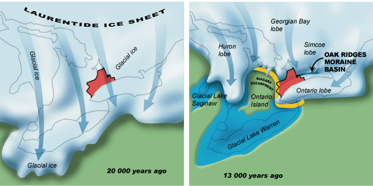
About 13 000 years ago, as the Laurentide Ice Sheet melted, glacial meltwater became ponded between the ice sheet and the Niagara Escarpment. This formed a lake basin into which gravel and sand were deposited from ice-bound tunnels. As the ice sheet melted, the ponded lake water drained, leaving the moraine high above the surrounding landscape.
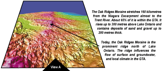
The Oak Ridges Moraine stretches 160 kilometres from the Niagara Escarpment almost to the Trent River. About 65% of it is within the GTA. It rises up to 300 metres above Lake Ontario and contains deposits of sand and gravel up to 200 metres thick.
Today, the Oak Ridges Moraine is the prominent ridge north of Lake Ontario. The ridge influences the flow of surface and groundwater, and local climate in the GTA.
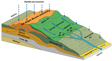
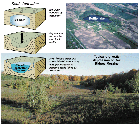
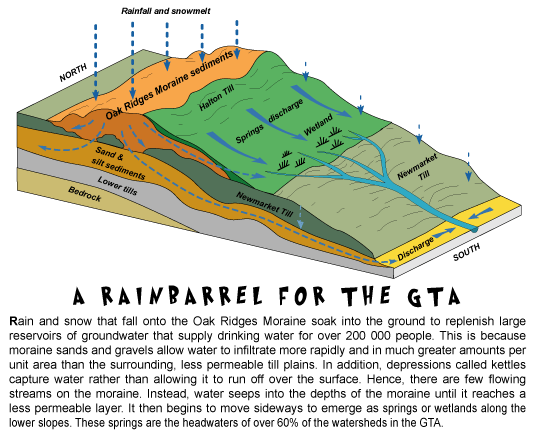
Rain and snow that fall onto the Oak Ridges Moraine soak into the ground to replenish large reservoirs of groundwater that supply drinking water for over 200 000 people. This is because moraine sands and gravels allow water to infiltrate more rapidly and in much greater amounts per unit area than the surrounding, less permeable till plains. In addition, depressions called kettles capture water rather than allowing it to run off over the surface. Hence, there are few flowing streams on the moraine. Instead, water seeps into the depths of the moraine until it reaches a less permeable layer. It then begins to move sideways to emerge as springs or wetlands along the lower slopes. These springs are the headwaters of over 60% of the watersheds in the GTA.
Almost 28% of the Oak Ridges Moraine is forested, compared to less than 5% in many parts of the GTA. These forests release oxygen into our air and are home to the rarest and greatest variety of plants and animals in the GTA. Because of urbanization, the moraine is the only remaining connection linking the watersheds in the GTA, and thus the green pathway that plants and animals will require to move between these watersheds. Recognizing the moraine's overall ecological significance, in late 2001 the government of Ontario enacted legislation and a plan to protect the moraine.
Sharpe, D.R. and Barnett, P.J., 1997; Where is the water? Regional Geological/hydrological Framework, Oak Ridges Moraine area, Southern Ontario, Field trip A1 Guidebook, Ottawa '97, Geological Association of Canada, 49p.
Sharpe, D.R. Barnett, P.J., Brennand, T.A., Finley, D., Gorrell, G., Russell, H.A.J. and Stacey, P., 1997; Surficial Geology of the Oak Ridges Moraine area, Southern Ontario, Geological Survey of Canada, Open File 3062, scale 1:200,000.


