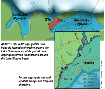
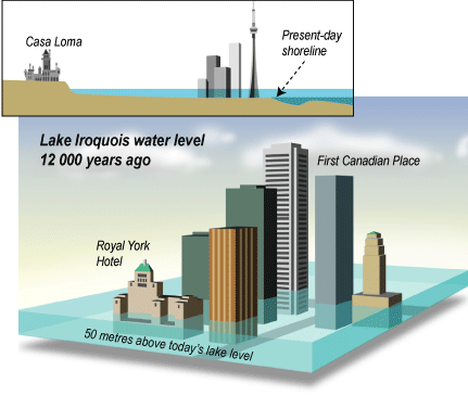
During the final retreat of the Laurentide Ice Sheet, ice blocked the St. Lawrence valley causing meltwater to flood the Lake Ontario basin and create glacial Lake Iroquois. Distinctive features of the Lake Iroquois shoreline are its prominent shorebluff, and large sand and gravel bars deposited in the Don and Humber river valleys. Downtown Toronto was submerged and is built on the old lake bottom. The Lake Iroquois shoreline also forms the headwaters for smaller streams such as Petticoat and Highland creeks. Sand and gravel deposited along the shore of Lake Iroquois were mined for construction and clay from the former lake bottom was used to make bricks.
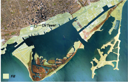
New Land for Toronto's Waterfront
Historically, the natural shore of Lake Ontario was at Front Street. Since the 1850s the Toronto shoreline has been extended almost 1 kilometre into the harbour by dumping millions of tonnes of fill. This originally provided land for industry and shipping. Now this land is used for condominiums, hotels, and parks. More recently, filling has occurred to reduce shoreline erosion and to build parks and marinas such as Bluffer's Park and Ontario Place.
Filling since 1850 has created lots of new land in the Toronto harbour area.
Shoreline Erosion and Repair
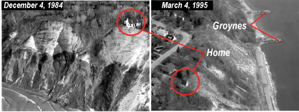
The steep cliffs of the Scarborough Bluffs are a result of various types of erosion. At the top, stormwater from roads and houses ran down the bluffs increasing natural erosion and several homes collapsed. To combat this, runoff from roads has been directed away from the bluffs. Along the face of the bluffs, water that has soaked into the ground erodes the bluffs where it seeps out. At the bottom, waves and storm surges from Lake Ontario have also caused erosion leading to the construction of low stone barriers at the base of the bluffs and the building of groynes at right angles to the shore to trap sediment and create small, protective beaches.
Home almost lost to erosion is moved back and saved by erosion-control measures.
http://www.torontobay.net/ Site related to Toronto Bay Initiative, which has a goal of regenerating the city's harbour into a healthy ecosystem
References:
Coleman, A.P., 1937; Lake Iroquois and the Geology of the North Shore of Lake Ontario, Ontario Department of Mines, 45th Annual Report, Volume XLV, Part VII.
Karrow, P.F. and Calking, P.E. (editors), 1985; Quaternary Evolution of the Great Lakes, Geological Association of Canada, Special paper 30.
Tovell, W.M., 1979; The Great Lakes, Royal Ontario Museum, Encounter Series.