CGEN Archive

Geoscape - Toronto

CGEN's Home Page
  • Home
  • CGEN Newsletter
    • CGEN Minutes
  • EarthLinks
  • EdGEO
    • Bringing Earth Science to Life
    • Putting the Earth into Science
  • FBY
    • FBY-Chapter Previews
    • FBY-Sample Lesson
    • QMA-Apercus des chapitres
  • Geoscape
    • Geoscape Canada >
      • Calgary
      • Fort Fraser
      • Montreal
      • Nanaimo
      • Northwest Territories
      • Ottawa-Gatineau
      • Québec
      • Saskatchewan-North
      • Saskatchewan-South
      • Toronto
      • Vancouver
      • Victoria
      • Whitehorse
    • Géopanorama du Canada
    • Geoscape Posters
    • Geotours
    • Waterscapes >
      • Bowen Island
      • Bow River Basin
      • Gulf Islands
      • Okanagan Basin
  • Geovistas
  • Key Publications
    • Wat On Earth
  • OGGP
  • Contact Us
Geoscape - Toronto
  • Home
  • Introduction
  • The Niagara Escarpment
  • Past and Present Lakeshores
  • The Oak Ridges Moraine
  • The Agricultural Plains
  • Rivers and Valley Lands
  • Teacher Resources
  • Credits & Citation
  • Poster Downloads

Geoscape - Toronto

Introduction

Picture
Ancient Foundations

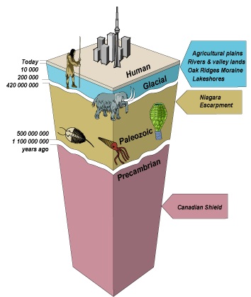
About 4.5 billion years ago the Earth was formed. The oldest rocks in southern Ontario are up to 1.5 billion years old and are tens of kilometres thick. Precambrian rocks of the Canadian Shield are visible at surface in Muskoka 'cottage country'. In the GTA the shield is covered by younger rocks and glacial sediments.

Imagine standing in downtown Toronto 20 000 years ago. You would be covered by an ice sheet four times as high as the CN Tower.

Yet, at the same place about 12 000 years ago when the ice sheet had melted back to Kingston you're now underwater. The ice-blocked St. Lawrence Valley cannot drain and Lake Ontario is 50 metres higher than today.

So you escape to the high ground of the Niagara Escarpment. Did you know that the rocks of the escarpment were deposited in a tropical sea over 420 million years ago?
Picture
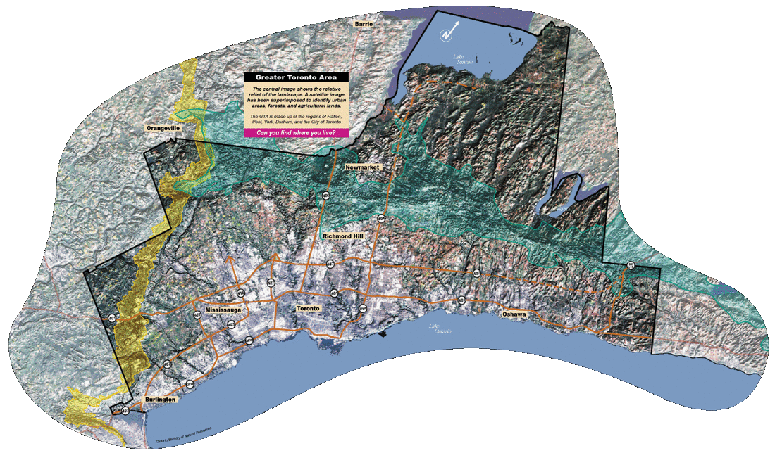
The geology below the ground and the landscape of the surface create a geoscape. Our geoscape influences natural conditions such as climate and flow of water and provides natural resources such as groundwater, forests, agricultural land, and construction materials.

Our quality of life therefore depends on understanding and effectively managing our geoscape.

Follow the story of 5 major elements in the Toronto Geoscape: the Niagara Escarpment, the Oak Ridges Moraine, lakeshores, rivers and valley lands, and the agricultural plains.

Introduction - Links & References

Great Changes in the Greater Toronto Area


A good starting point:
  • http://www.lostrivers.ca/points/pin.html#ice (Site on Natural features around GTA.)
Additional resources:
  • http://www.rocksforkids.com/index.html (Site for kids on rocks and minerals.)
  • http://www.earth.uwaterloo.ca/services/whaton/waton/watonf00.html(University of Waterloo's site with geology articles for students and teachers.)

References:
  • Eyles, N., 2002; Ontario Rocks - three billion years of environmental change, Fitzhenry & Whiteside, Markham, Ontario, 338p.
  • Eyles, N. and Clinton, L, 1998; Toronto Rocks - The Geological Legacy of the Toronto Region, University of Toronto - Scarborough, 40p.
  • Freeman, E.B., 1976; Toronto's Geological Past - An Introduction, Ontario Division of Mines, Miscellaneous Publication - brochure.
  • Roots, B.I., 1999; Special Places - The Changing Ecosystems of the Toronto Region, UBC Press, Vancouver, BC, 342p.
Géopanorama du Canada
Geoscapes:
  • Canada
  • Calgary
  • Fort Fraser
  • Montreal
  • Nanaimo
  • Northwest Territories
  • Ottawa-Gatineau
  • Québec
  • Saskatchewan - North
  • Saskatchewan - South
  • Toronto
  • Vancouver
  • Victoria
  • Whitehorse
Copyright CGEN 2014-2020
​ Quick Links to Earth Sciences Canada sites
​Earthlinks | WHERE Challenge | Careers in Earth Science |  Four Billion Years and Counting | IYPE | CFES | CGEN | IUGS | GeoVistas | OGGP