Why Floods Happen Flooding is a natural process. It happens when a river overtops its banks and inundates nearby low-lying areas. In communities built on these floodplains, properties, roads, bridges, and railways can be damaged or destroyed by high water levels and sometimes by moving ice. Floods can be caused by rapid melting of large amounts of snow, or rain on snow, or prolonged or torrential rainfall. Ice jams and landslide debris can also temporarily block a river, causing upstream flooding.
The 100-year flood - Not every 100 years! The '100-year flood' refers to the flood level that has a 1% chance of occurring in any given year, and thus may actually occur more often than once in a century or, alternatively, not happen at all. The magnitude of the 100-year flood is commonly used to define flood zones and to design flood-protection structures such as dikes.
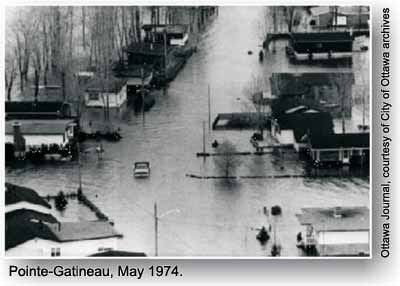
Defending Against Floods Flood damages can be reduced substantially by avoiding development on flood-prone lands. Parks (such as Brewer Park along the Rideau River and Leamy Park in Gatineau) playing fields, and natural areas are appropriate land use for these flood-prone areas. Dikes, elevated embankments that provide a physical barrier between low-lying land and the river, can protect developments on the floodplain. A dike along the Gatineau River protects part of Gatineau. Although the reservoirs are too small to control flood discharge, the many power dams along the Ottawa River can alert downstream communities of potential flood conditions.
Did you know?... To prevent ice-jam floods within Ottawa, the ice on the lower Rideau River is broken up each year during late winter by sawing and blasting, or by an amphibious backhoe.