CGEN Archive

Geoscape - Ottawa-Gatineau

CGEN's Home Page
  • Home
  • CGEN Minutes
  • EarthLinks
  • EdGEO
    • Bringing Earth Science to Life
    • Putting the Earth into Science
  • FBY
    • FBY-Chapter Previews
    • FBY-Sample Lesson
    • QMA-Apercus des chapitres
  • Geoscape
    • Geoscape Canada >
      • Calgary
      • Fort Fraser
      • Montreal
      • Nanaimo
      • Northwest Territories
      • Ottawa-Gatineau
      • Québec
      • Saskatchewan-North
      • Saskatchewan-South
      • Toronto
      • Vancouver
      • Victoria
      • Whitehorse
    • Géopanorama du Canada
    • Geoscape Posters
    • Geotours
    • Waterscapes >
      • Bowen Island
      • Bow River Basin
      • Gulf Islands
      • Okanagan Basin
  • Geovistas
  • Key Publications
    • Wat On Earth
  • OGGP
  • Contact Us
Geoscape - Ottawa-Gatineau
  • Home
  • Deep Time
  • Changing Landscape
  • Different Rocks
  • Wealth From the Land
  • Ottawa River
  • Groundwater
  • Flooding
  • Landslides
  • Earthquakes
  • Indoor Radon
  • Land Use
  • Teacher Resources
  • Credits & Citation
  • Poster Downloads

Geoscape - Ottawa-Gatineau

Earthquakes

Why do we have earthquakes?

The Ottawa-Gatineau region is located far from active tectonic plate boundaries, the usual source of earthquakes, but it does have a seismic history.  Within this region, the Earth's crust is being compressed.  Once the accumulated stress exceeds the strength of the crust, it is released by slippage along reactivated faults of the Ottawa-Bonnechere graben.  Although this area has a moderate risk of a damaging earthquake, a devastating earthquake is unlikely.

What We Feel

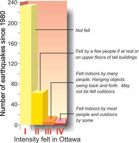
Magnitude (Richter scale), or size, reflects the amount of fault movement at the source of an earthquake.  However, because the strength of shaking generally decreases with distance from the epicentre, what we feel and the amount of damage differ from place to place.  Intensity is a measure of shaking at a specific place and ranges from I to XII (modified Mercalli scale). For any earthquake there will be one magnitude and many intensities.
Picture
Did you know?... 
On average, we feel an earthquake of intensity III or higher once every 3 years in Ottawa-Gatineau.

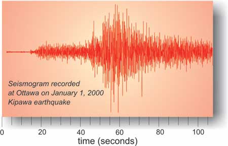
Ottawa-Gatineau was shaken into the year 2000 by a magnitude 5.2 earthquake centred at Kipawa, north of North Bay, about 300 km from Ottawa. In Ottawa, this event had a felt intensity of III.
Picture
Protecting Ourselves

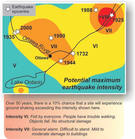
By evaluating the local history of earthquakes and the local geology, seismologists can produce maps predicting maximum ground motion or intensity for a region. Seismological data are used to set our national building codes that specify the engineering design requirements for earthquake-resistant buildings.
Picture
Géopanorama du Canada
Geoscapes:
  • Canada
  • Calgary
  • Fort Fraser
  • Montreal
  • Nanaimo
  • Northwest Territories
  • Ottawa-Gatineau
  • Québec
  • Saskatchewan - North
  • Saskatchewan - South
  • Toronto
  • Vancouver
  • Victoria
  • Whitehorse
Copyright CGEN 2014-2021
​ Quick Links to Earth Sciences Canada sites
​Earthlinks | WHERE Challenge | Careers in Earth Science |  Four Billion Years and Counting | IYPE | CFES | CGEN | IUGS | GeoVistas | OGGP