CGEN Archive

Geoscape - Fort Fraser

CGEN's Home Page
  • Home
  • CGEN Newsletter
    • CGEN Minutes
  • EarthLinks
  • EdGEO
    • Bringing Earth Science to Life
    • Putting the Earth into Science
  • FBY
    • FBY-Chapter Previews
    • FBY-Sample Lesson
    • QMA-Apercus des chapitres
  • Geoscape
    • Geoscape Canada >
      • Calgary
      • Fort Fraser
      • Montreal
      • Nanaimo
      • Northwest Territories
      • Ottawa-Gatineau
      • Québec
      • Saskatchewan-North
      • Saskatchewan-South
      • Toronto
      • Vancouver
      • Victoria
      • Whitehorse
    • Géopanorama du Canada
    • Geoscape Posters
    • Geotours
    • Waterscapes >
      • Bowen Island
      • Bow River Basin
      • Gulf Islands
      • Okanagan Basin
  • Geovistas
  • Key Publications
    • Wat On Earth
  • OGGP
  • Contact Us
Geoscape - Fort Fraser
  • Home
  • Modern Sediments
  • Ice Age Sediments
  • Bedrock
  • Landforms Left by Glaciers
  • Mercury in the Environment
  • Groundwater - Vital But Vulnerable
  • Geological Controls on Fish Habitat
  • Earth Material Characteristics
  • Molybdenum in the Environment
  • Credits & Citations
  • Poster Downloads

Geoscape - Fort Fraser

Mercury in the Environment

Mercury in the Environment
PDF version [PDF, 375.0 kb]
Picture
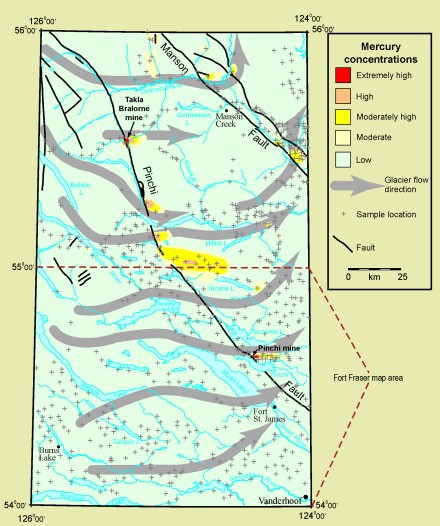
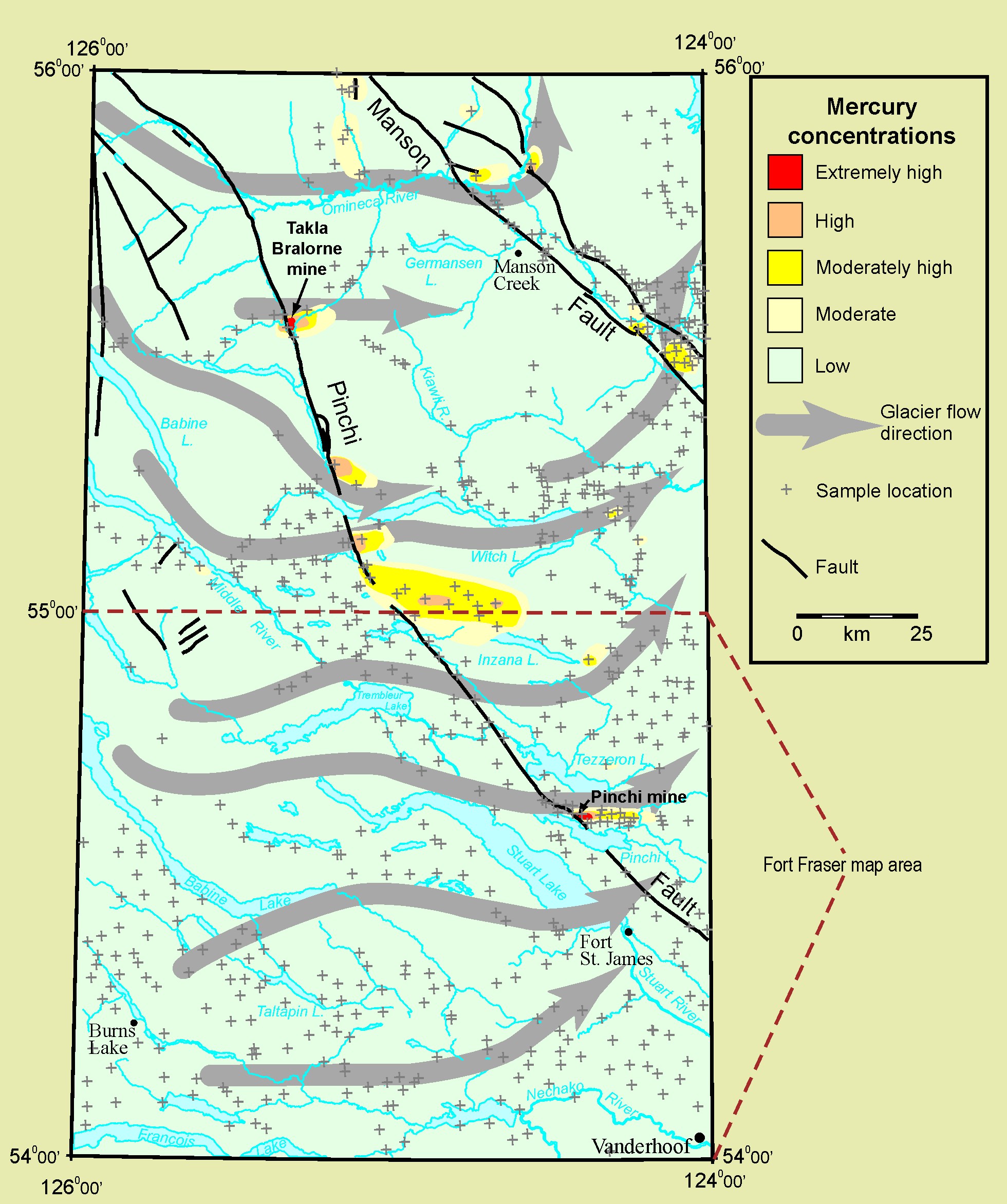
The Pinchi Fault crosses the northeastern Fort Fraser map area and has a total length of 470 km. Minerals enriched in mercury occur naturally along the fault and were deposited by ancient hot fluids. The Pinchi and Takla Bralorne mines, the only two mines (now inactive) to have produced mercury in Canada, were located along the Pinchi Fault. Mercury concentrations in till are extremely high near both mines and are high at other localities up to several kilometres east of the fault. During the last glaciation, glaciers eroded bedrock and sediments which were enriched in mercury and were transported in an easterly or down-ice direction.

The areal extent of high mercury concentrations in till, on the scale of kilometres, is much greater than the extent of the mercury mineralization in bedrock, which occurs on the scale of tens or hundreds of metres, along the Pinchi Fault. Geologists look for these large anomalous zones in till and then trace them "up-ice" to their bedrock source.

The presence of mercury in central British Columbia is of particular interest because of its economic value and environmental impacts. Natural processes convert small amounts of mercury to the highly toxic methyl mercury form. Fish and other wildlife can accumulate methyl mercury in their muscle tissues and other parts of their system. Human consumption of these animals in sufficient quantity can lead to health problems.

Mercury in the Environment
Smaller Image [JPEG]
Larger image [JPEG, 702.0 kb, 1960 X 2343]
PDF version [PDF, 375.0 kb]
Géopanorama du Canada
Geoscapes:
  • Canada
  • Calgary
  • Fort Fraser
  • Montreal
  • Nanaimo
  • Northwest Territories
  • Ottawa-Gatineau
  • Québec
  • Saskatchewan - North
  • Saskatchewan - South
  • Toronto
  • Vancouver
  • Victoria
  • Whitehorse

Copyright CGEN 2014-2020
​ Quick Links to Earth Sciences Canada sites
​Earthlinks | WHERE Challenge | Careers in Earth Science |  Four Billion Years and Counting | IYPE | CFES | CGEN | IUGS | GeoVistas | OGGP