CGEN Archive

Geoscape - Fort Fraser

CGEN's Home Page
  • Home
  • CGEN Minutes
  • EarthLinks
  • EdGEO
    • Bringing Earth Science to Life
    • Putting the Earth into Science
  • FBY
    • FBY-Chapter Previews
    • FBY-Sample Lesson
    • QMA-Apercus des chapitres
  • Geoscape
    • Geoscape Canada >
      • Calgary
      • Fort Fraser
      • Montreal
      • Nanaimo
      • Northwest Territories
      • Ottawa-Gatineau
      • Québec
      • Saskatchewan-North
      • Saskatchewan-South
      • Toronto
      • Vancouver
      • Victoria
      • Whitehorse
    • Géopanorama du Canada
    • Geoscape Posters
    • Geotours
    • Waterscapes >
      • Bowen Island
      • Bow River Basin
      • Gulf Islands
      • Okanagan Basin
  • Geovistas
  • Key Publications
    • Wat On Earth
  • OGGP
  • Contact Us
Geoscape - Fort Fraser
  • Home
  • Modern Sediments
  • Ice Age Sediments
  • Bedrock
  • Landforms Left by Glaciers
  • Mercury in the Environment
  • Groundwater - Vital But Vulnerable
  • Geological Controls on Fish Habitat
  • Earth Material Characteristics
  • Molybdenum in the Environment
  • Credits & Citations
  • Poster Downloads

Geoscape - Fort Fraser

Geological Controls on Fish Habitat

Geological Controls on Fish Habitat
PDF version [PDF, 401.3 kb]
Picture
The headwaters of the Fraser and Skeena rivers occur in the Fort Fraser map area. Large numbers of Pacific salmon spawn in streams in these headwater areas. Lakes and streams feeding the Stuart and Nechako rivers host salmon that have travelled up the Fraser River, and lakes and streams feeding Babine Lake and Babine River host salmon that have travelled up the Skeena River.

The map area has abundant habitat for fresh water and spawning marine fishes. Factors that influence the quality of the fish habitat include water temperature, water chemistry, and the stream sediment load.

Water Temperature

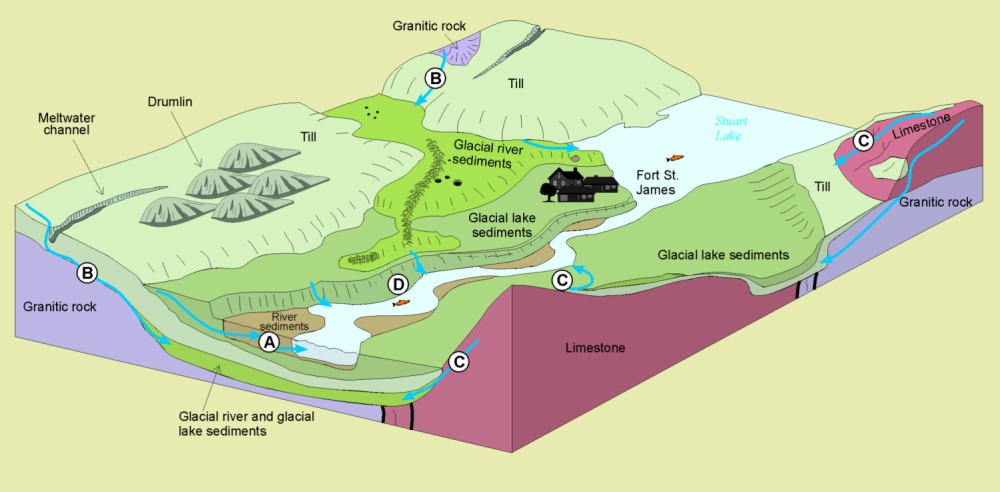
Pacific salmon prefer cool waters. In summer and fall, when salmon spawn, groundwater is generally cooler than surface water. Groundwater discharge into lakes and rivers (A) maintains cooler water temperatures during hot weather. Without groundwater inflow, stream temperatures could reach levels harmful to salmon.

Water Chemistry

Fish prefer neutral to alkaline waters. Surface water and groundwater are generally more acidic in areas underlain by granitic rock (B) than in areas of limestone (C).

Sediment Load

Fish spawning habitat can be damaged if streams deposit silt in their channels. Sediment in streams in the Fort Fraser map area is primarily derived from glacial river deposits (sand and gravel), till, and glacial lake sediments (sand, silt and clay). Natural siltation is highest in areas where streams cut into banks of glacial lake sediments, such as along the Stuart and Nechako (D).

Geological Controls on Fish Habitat
Smaller Image [JPEG]
Larger image [JPEG, 76.1 kb, 1000 X 492]
PDF version [PDF, 401.3 kb]
Géopanorama du Canada
Geoscapes:
  • Canada
  • Calgary
  • Fort Fraser
  • Montreal
  • Nanaimo
  • Northwest Territories
  • Ottawa-Gatineau
  • Québec
  • Saskatchewan - North
  • Saskatchewan - South
  • Toronto
  • Vancouver
  • Victoria
  • Whitehorse

Copyright CGEN 2014-2021
​ Quick Links to Earth Sciences Canada sites
​Earthlinks | WHERE Challenge | Careers in Earth Science |  Four Billion Years and Counting | IYPE | CFES | CGEN | IUGS | GeoVistas | OGGP