Groundwater - Vital But Vulnerable PDF version [PDF, 446.7 kb]
Groundwater is an important resource in the Fort Fraser map area because it is used in many homes and for livestock.
What is Groundwater?
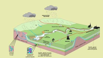
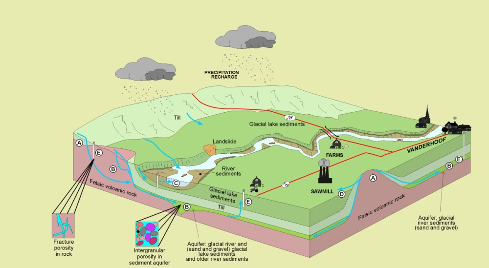
When precipitation or surface water infiltrates permeable soil, sediments or bedrock, it becomes groundwater A. Groundwater can be produced from wells that intersect higher porosity and permeability zones B (aquifer). Groundwater may flow into streams and lakes C, or discharge at the surface as a spring D. Wells tap into aquifers E.
Groundwater Resources
The most important aquifers in the Fort Fraser map area are comprised of sand and/or gravel found in modern river sediments and older glacial and nonglacial deposits. Most of the wells in this region have low yields (less than one litre per second), but there are several high yield wells (tens of litres per second) near Vanderhoof and Fort St. James that produce from buried glacial river sand and gravel aquifers.
Most groundwater in the region is moderately to very hard. Concentrations of iron, manganese, and uranium in groundwater in the Endako and Burns Lake area locally exceed recommended concentrations.
Groundwater Chemistry and Contamination
Groundwater chemistry is determined by the composition of the bedrock and sediments through which the water flows and by some human activities. Some groundwater has low concentrations of dissolved solids and is well suited for municipal use. Hard water, in contrast, contains high levels of dissolved solids which limit its use.
Groundwater can be contaminated by seepage from sanitary landfills, chemical spills, manure piles, mine tailing ponds, sewage lagoons, woodchip piles at sawmills, and buried industrial tanks. Contamination also results from application of herbicides, fungicides, and insecticides to agricultural land. The more vulnerable aquifers include the river sediments and some of the unconfined glacial river sand and gravel sediments found in the area.