CGEN Archive

Geoscape - Fort Fraser

CGEN's Home Page
  • Home
  • CGEN Newsletter
    • CGEN Minutes
  • EarthLinks
  • EdGEO
    • Bringing Earth Science to Life
    • Putting the Earth into Science
  • FBY
    • FBY-Chapter Previews
    • FBY-Sample Lesson
    • QMA-Apercus des chapitres
  • Geoscape
    • Geoscape Canada >
      • Calgary
      • Fort Fraser
      • Montreal
      • Nanaimo
      • Northwest Territories
      • Ottawa-Gatineau
      • Québec
      • Saskatchewan-North
      • Saskatchewan-South
      • Toronto
      • Vancouver
      • Victoria
      • Whitehorse
    • Géopanorama du Canada
    • Geoscape Posters
    • Geotours
    • Waterscapes >
      • Bowen Island
      • Bow River Basin
      • Gulf Islands
      • Okanagan Basin
  • Geovistas
  • Key Publications
    • Wat On Earth
  • OGGP
  • Contact Us
Geoscape - Fort Fraser
  • Home
  • Modern Sediments
  • Ice Age Sediments
  • Bedrock
  • Landforms Left by Glaciers
  • Mercury in the Environment
  • Groundwater - Vital But Vulnerable
  • Geological Controls on Fish Habitat
  • Earth Material Characteristics
  • Molybdenum in the Environment
  • Credits & Citations
  • Poster Downloads

Geoscape - Fort Fraser

  • Landforms Left by Glaciers

Landforms Left by Glaciers
PDF version [PDF, 383.2 kb]
Picture
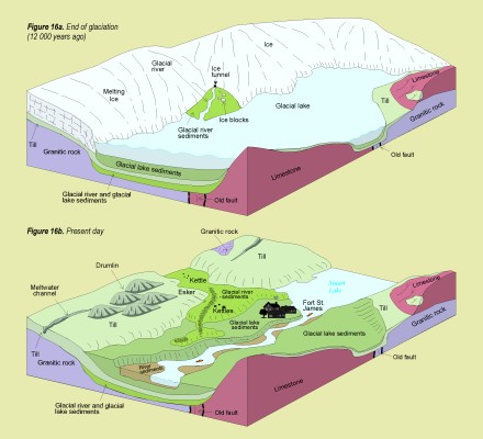
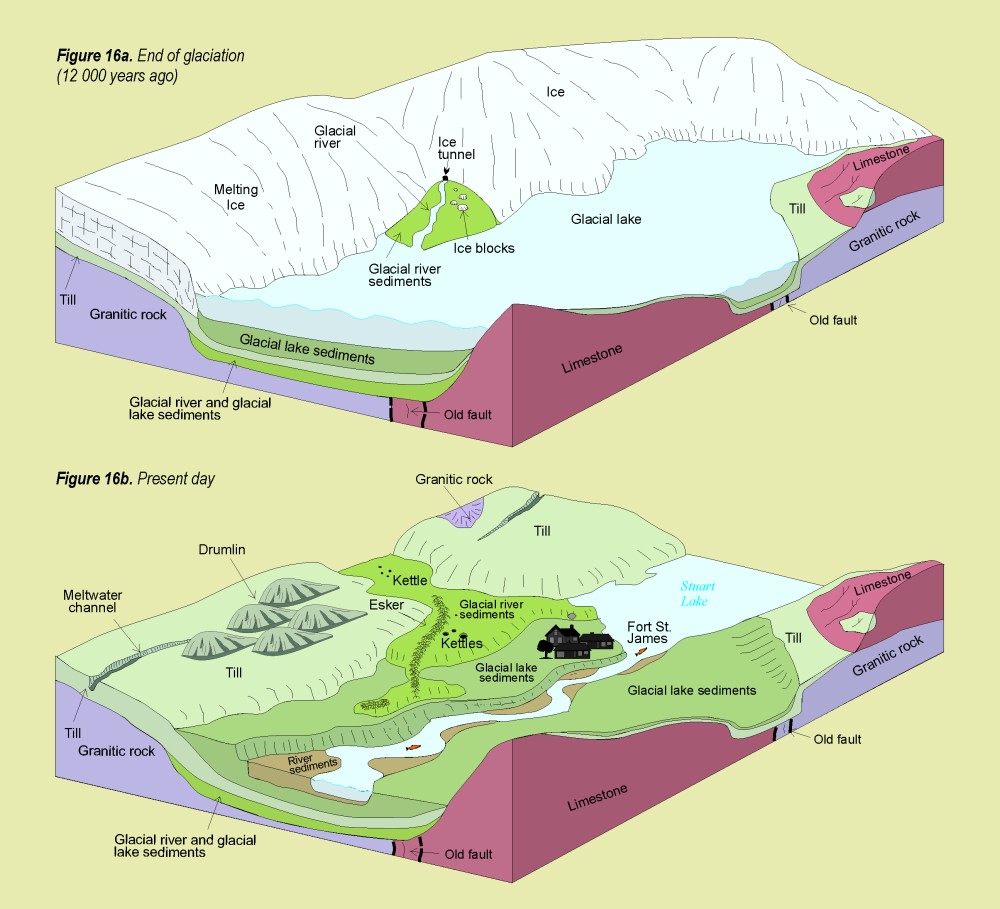
Figure 16a. End of glaciation (12,000 years ago) 
Figure 16b. Present day

Climatic fluctuations during the Pleistocene Epoch (2 000 000 to 10 000 years ago) caused glaciers to grow and decay. As the last ice sheet that covered British Columbia retreated at the end of the Pleistocene, it left behind many distinctive landforms and sediments.

During the last glaciation, east-flowing glaciers scoured the bedrock and deposited till, a poorly sorted sediment containing stones up to boulder size. Till blankets flat to moderately sloping terrain above the valley floor. Elongate and spoon-shaped hills of glacial debris (drumlins) are oriented parallel to the direction of glacier flow.

Streams of meltwater flowed through tunnels within, beneath, and on the glaciers. Sand and gravel accumulated in these tunnels, forming long, narrow, sinuous ridges (eskers). The ridges are an excellent source of sand and gravel. Where meltwater streams flowed away from the ice front, they deposited sand and gravel as outwash fans and outwash plains. Isolated and buried ice blocks in the outwash melted to form depressions known as kettles. Meltwater was also dammed in places by ice or sediments, forming glacial lakes. When the ice sheet disappeared, the lakes drained, leaving behind nutrient-rich silty and clayey sediments that form some of the best agricultural land in central British Columbia.

Landforms Left by Glaciers
Smaller Image [JPEG]
Larger image [JPEG, 143.7 kb, 1000 X 909]
PDF version [PDF, 383.2 kb]
Géopanorama du Canada
Geoscapes:
  • Canada
  • Calgary
  • Fort Fraser
  • Montreal
  • Nanaimo
  • Northwest Territories
  • Ottawa-Gatineau
  • Québec
  • Saskatchewan - North
  • Saskatchewan - South
  • Toronto
  • Vancouver
  • Victoria
  • Whitehorse

Copyright CGEN 2014-2020
​ Quick Links to Earth Sciences Canada sites
​Earthlinks | WHERE Challenge | Careers in Earth Science |  Four Billion Years and Counting | IYPE | CFES | CGEN | IUGS | GeoVistas | OGGP