CGEN Archive

Waterscape Canada

CGEN's Home Page
  • Home
  • CGEN Newsletter
    • CGEN Minutes
  • EarthLinks
  • EdGEO
    • Bringing Earth Science to Life
    • Putting the Earth into Science
  • FBY
    • FBY-Chapter Previews
    • FBY-Sample Lesson
    • QMA-Apercus des chapitres
  • Geoscape
    • Geoscape Canada >
      • Calgary
      • Fort Fraser
      • Montreal
      • Nanaimo
      • Northwest Territories
      • Ottawa-Gatineau
      • Québec
      • Saskatchewan-North
      • Saskatchewan-South
      • Toronto
      • Vancouver
      • Victoria
      • Whitehorse
    • Géopanorama du Canada
    • Geoscape Posters
    • Geotours
    • Waterscapes >
      • Bowen Island
      • Bow River Basin
      • Gulf Islands
      • Okanagan Basin
  • Geovistas
  • Key Publications
    • Wat On Earth
  • OGGP
  • Contact Us

Waterscape - Bowen Island

Hydropanoramas
  • Home
  • How we use it
  • Water shortages?
  • How we get it
  • The Clean Water Factory
  • Water Stored Underground
  • Reducing Risks
  • Living with summer drought
  • Credits & Citation
  • Poster Downloads
Water shortages? But this is a rainforest!

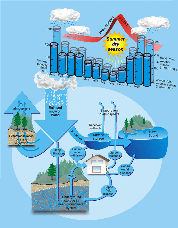
It all falls from the sky.
Rainfall feeds Bowen Island's entire fresh water supply. Moisture from the Pacific Ocean is blown eastwards and falls as rain. Rainwater flows into streams to be carried quickly to the sea (perhaps with a pause in wetlands or lakes) or sinks into the ground to join the slow-moving groundwater system. Shallow groundwater returns to the surface as springs, adding flow to streams. The island's fresh groundwater is entirely surrounded by salty groundwater that underlies the seafloor.
Picture
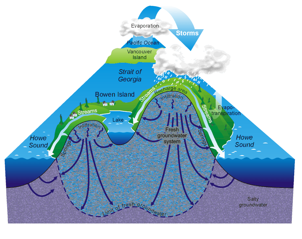
Mystery Stream Supply
Some streams on Bowen Island flow year round, even through the summer dry season. When it hasn't rained for weeks, where can the water be coming from?

​My water comes from Mount Baker!

There is no scientific evidence for beliefs that some of our springs or wells flow from Mount Baker or the north shore. All indications point to island rainfall as the only source of Bowen Island's fresh water.
Are more droughts coming?
Scientists predict that in the future southwestern British Columbia will receive more winter rainfall, but longer and hotter summer dry seasons. How will this effect the supply of water on Bowen Island?
Picture
Limited resupply!
Based on research in the San Juan Islands, it is estimated that only a small per cent of our annual rainfall, likely less than 15 cm of rainwater, becomes part of deep groundwater storage.
The Problem: 
Our Summer Dry Season

How can we have water shortages when we get so much rain? Because so much of our 1.5-1.8 m of annual rainfall comes during the winter and runs quickly to the sea. The land can't store enough of our winter rains, so water shortages occur during the summer dry season.
Picture
Summer dry season
Doing the Math: Not Much Storage
Most rainwater returns to the atmosphere through plants and evaporation. Much of the rest is carried quickly to the sea by streams. Some stream water is stored for days to months in wetlands, ponds, lakes, and reservoirs. A small amount infiltrates the ground, evades capture by plant roots, and can be stored for months to centuries in the slow-moving groundwater system.
Waterscapes:
  • Bowen Island 
  • Bow River Basin
  • Gulf Islands
  • Okanagan Basin ​
Copyright CGEN 2014-2020
​ Quick Links to Earth Sciences Canada sites
​Earthlinks | WHERE Challenge | Careers in Earth Science |  Four Billion Years and Counting | IYPE | CFES | CGEN | IUGS | GeoVistas | OGGP