CGEN Archive

Waterscape Canada

CGEN's Home Page
  • Home
  • CGEN Newsletter
    • CGEN Minutes
  • EarthLinks
  • EdGEO
    • Bringing Earth Science to Life
    • Putting the Earth into Science
  • FBY
    • FBY-Chapter Previews
    • FBY-Sample Lesson
    • QMA-Apercus des chapitres
  • Geoscape
    • Geoscape Canada >
      • Calgary
      • Fort Fraser
      • Montreal
      • Nanaimo
      • Northwest Territories
      • Ottawa-Gatineau
      • Québec
      • Saskatchewan-North
      • Saskatchewan-South
      • Toronto
      • Vancouver
      • Victoria
      • Whitehorse
    • Géopanorama du Canada
    • Geoscape Posters
    • Geotours
    • Waterscapes >
      • Bowen Island
      • Bow River Basin
      • Gulf Islands
      • Okanagan Basin
  • Geovistas
  • Key Publications
    • Wat On Earth
  • OGGP
  • Contact Us

Waterscape - Bowen Island

Hydropanoramas
  • Home
  • How we use it
  • Water shortages?
  • How we get it
  • The Clean Water Factory
  • Water Stored Underground
  • Reducing Risks
  • Living with summer drought
  • Credits & Citation
  • Poster Downloads
Water in our lives: How we get it.

Diverse Water Sources
Unlike Vancouverites, whose water comes from a few large mountain reservoirs, Bowen Islanders get their water from diverse sources such as reservoirs, wells, and streams. Increasingly, islanders are also using rooftop water.
Picture
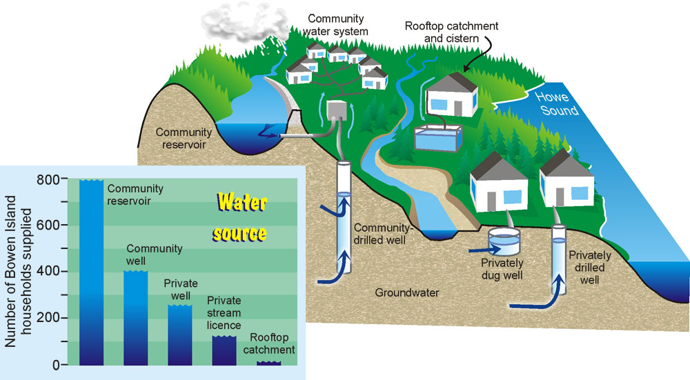
Different water sources on Bowen Island

Picture
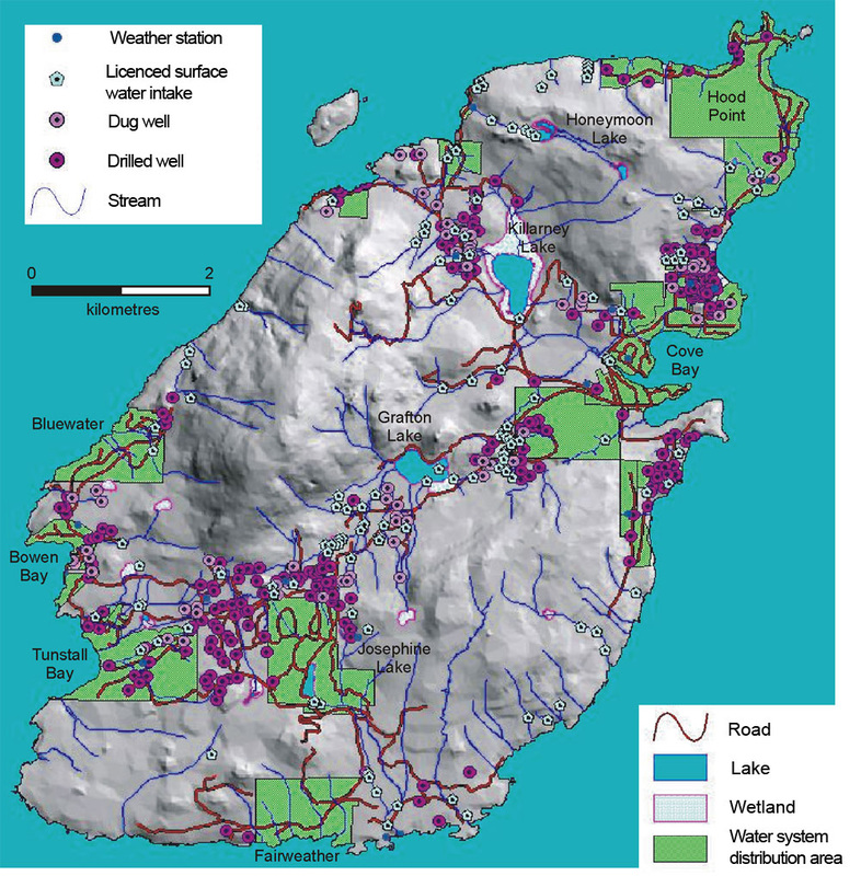
A map of Bowen Island showing sources of water

​Water: The Local Resource

Think about it. Most of the food, energy, and manufactured goods come from far away. Only our water is home grown. Almost all of it comes from Bowen Island. So we control the future of our water. It's for us to decide!
Picture
Picture
Bottled water - the foreign invasion!
Bottled water has become very popular. While it seems safe and convenient, there are disadvantages: it's expensive, it creates waste containers, and trucking water generates air pollution, causing problems like asthma and global warming.

Watersheds everywhere!
All the land area that drains into a stream system is called a watershed. Most areas of Bowen Island drain into some stream, so it is likely that you live in a watershed. A water-supply watershed is the part of a watershed upstream of a water-supply intake. Many parts of Bowen Island are water-supply watershed areas. Do you live in one?
Picture
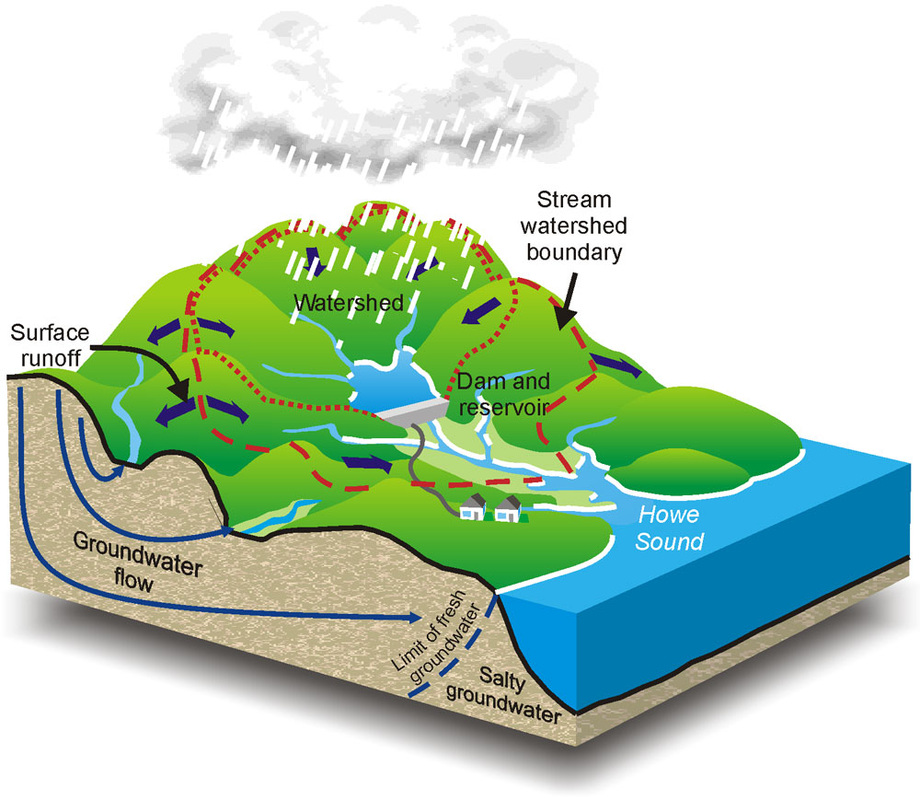
Living in our water: Supply Watersheds
Vancouver protects water quality in its watersheds by restricting access. Things are different on Bowen Island. Some water-supply watersheds lie within forested Crown Lands and are relatively pristine. But others, such as the Grafton Lake water supply, include residential and commercial areas, roads, and livestock. All of these uses represent potential sources of contamination. Should we be concerned?
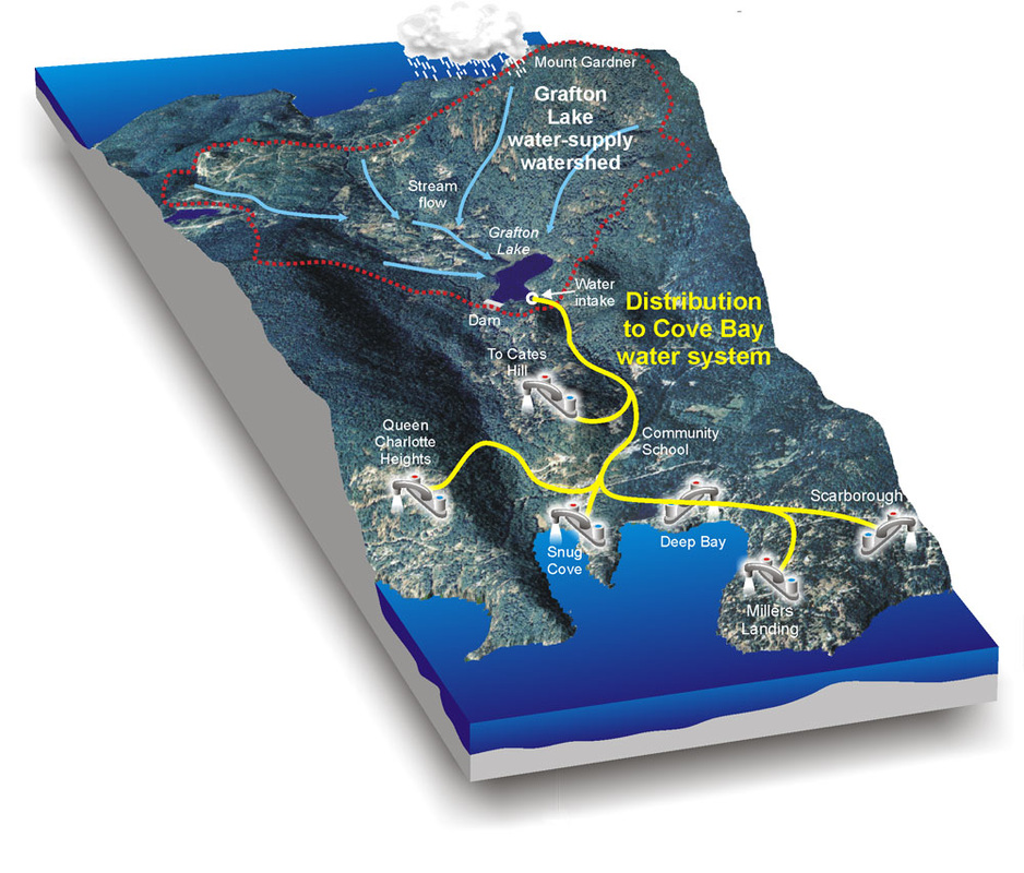
Picture
Waterscapes:
  • Bowen Island 
  • Bow River Basin
  • Gulf Islands
  • Okanagan Basin ​
Copyright CGEN 2014-2020
​ Quick Links to Earth Sciences Canada sites
​Earthlinks | WHERE Challenge | Careers in Earth Science |  Four Billion Years and Counting | IYPE | CFES | CGEN | IUGS | GeoVistas | OGGP