The Clean Water Factory:
|
|
Hi-tech forests?
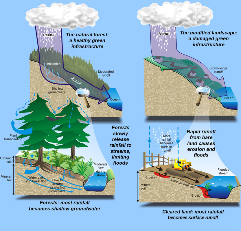
How they work for us. Our forests, streams, lakes, and wetlands provide an amazing service to us, clean water! They have evolved over millions of years of 'research and development'. Forests act as a giant filter. Rain infiltrates the porous organic soils and percolates slowly to streams where it is gradually released as clear water. As a result, forest streams commonly run clear even during storms. |
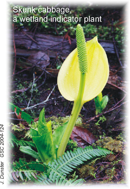
Skunk cabbage,
a wetland indicator plant (J. Dunster GSC 2004-124) |
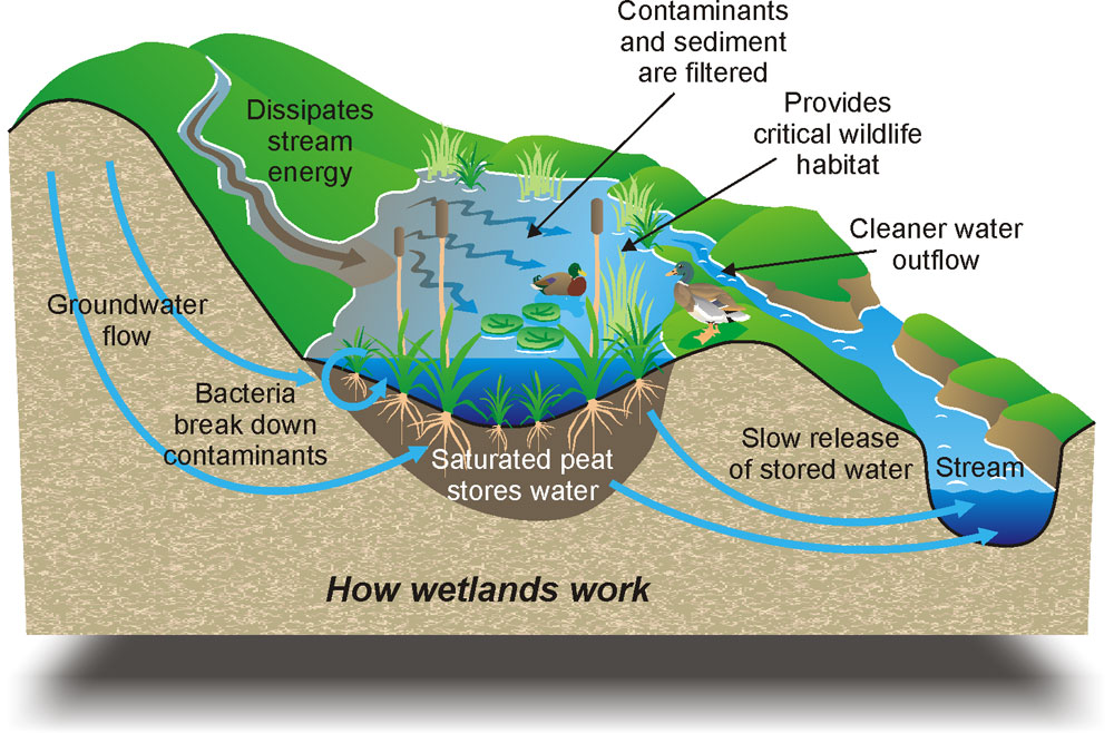
Wetlands: Nature's Sponge & Filter
Wetlands, swamps, marshes, bogs, and fens provide many services. They filter stream waters, store water, and offer critical habitat for many plants and animals. Wetlands fill with water during rains and slowly release water through droughts. Before we understood their critical role, we used to ditch and drain wetlands to create lawns, pastures, or farms.
Wetlands, swamps, marshes, bogs, and fens provide many services. They filter stream waters, store water, and offer critical habitat for many plants and animals. Wetlands fill with water during rains and slowly release water through droughts. Before we understood their critical role, we used to ditch and drain wetlands to create lawns, pastures, or farms.
Stream 'Tornadoes'
In contrast to forests, rain does not easily infiltrate bare mineral soils exposed in disturbed areas. Instead, rainwater flows on the surface, eroding and carrying away fine sediment. During storms, streams flood quickly with muddy waters, eroding banks and filling channels with sediment. Such floods are like a tornado, wreaking havoc to stream life.
In contrast to forests, rain does not easily infiltrate bare mineral soils exposed in disturbed areas. Instead, rainwater flows on the surface, eroding and carrying away fine sediment. During storms, streams flood quickly with muddy waters, eroding banks and filling channels with sediment. Such floods are like a tornado, wreaking havoc to stream life.
A little mud never hurt anyone - or did it?
|
Muddy water or turbidity is a major water contaminant on Bowen Island. Turbidity plays havoc with water treatment systems, reducing the ability of chlorine to disinfect. Muddy water also degrades stream gravel. The spaces in clean gravels are home to all kinds of life: fish eggs, insects, and even small fish. Silt clogs these pore spaces, reducing life in the stream.
Are ditches a part of stream systems? You bet! Construction of ditches have added many miles to our stream system. Many small streams drain into ditches, and most ditches drain back into streams. So whatever goes into ditches, ends up in our streams! |
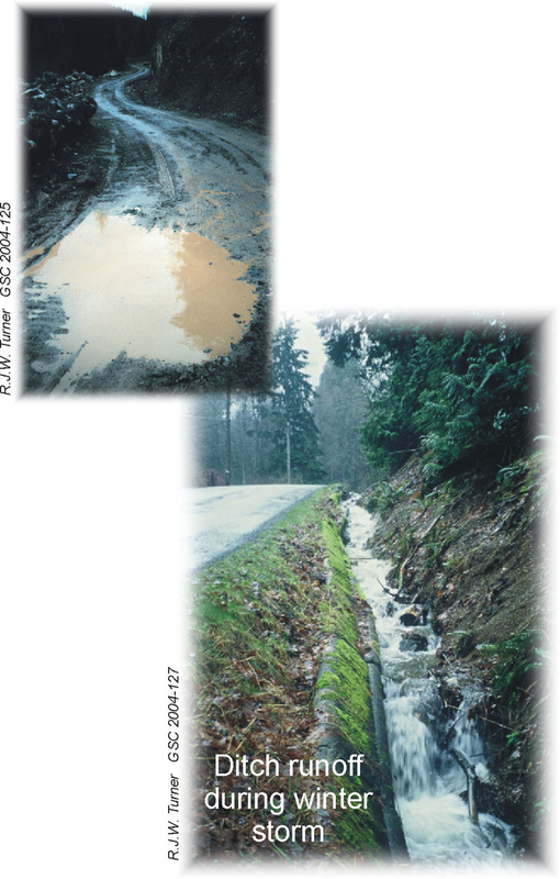
Ditch runoff during winter storm
|
Green infrastructure? What's that?
Our forests, streams, lakes, and wetlands provide us with vital water supply and filtration services. Like roads, power lines, and water pipeline systems, they are essential infrastructure that we depend on. Just like these other services, our green infrastructure requires investment, maintenance, and repair.
Our forests, streams, lakes, and wetlands provide us with vital water supply and filtration services. Like roads, power lines, and water pipeline systems, they are essential infrastructure that we depend on. Just like these other services, our green infrastructure requires investment, maintenance, and repair.
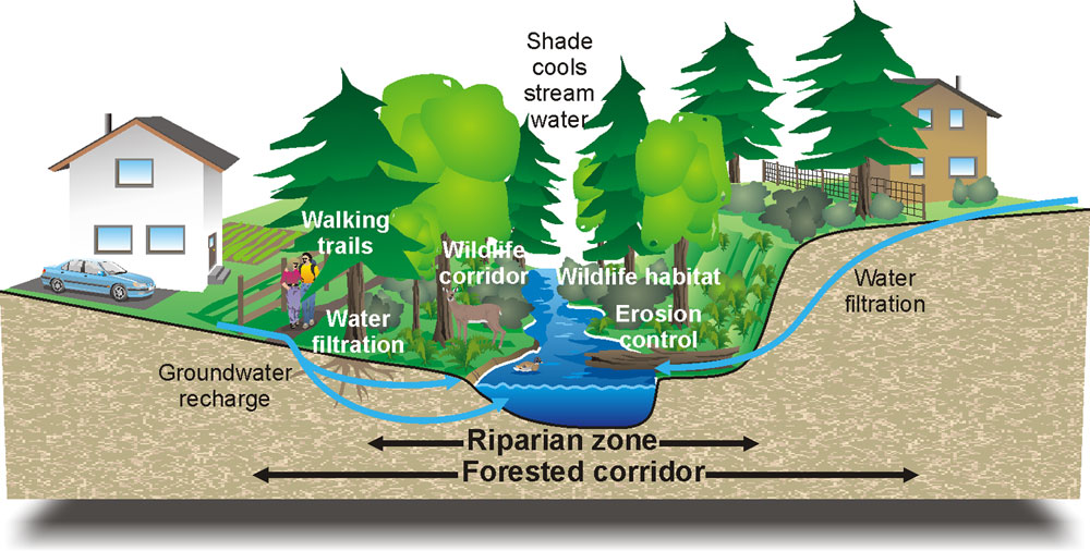
Forested corridors: vital to stream health
Maintaining forest corridors along our streams is essential to stream health. Forests filter water, provide shade to cool waters during summer heat, provide logs that create pools and riffles, and provide wildlife travel corridors and habitat. They also provide walking trails for us!
Investing in Greenways:
Our Recent Progress
Bowen Island's green infrastructure is in good condition. We invest in it by protecting it as parkland. Over the last several years, Bowen Island Municipality has negotiated green infrastructure protection with landowners seeking to develop their lands.
Below: A network of greenways has protected streams, wetlands, and lakes in the Josephine Lake area.
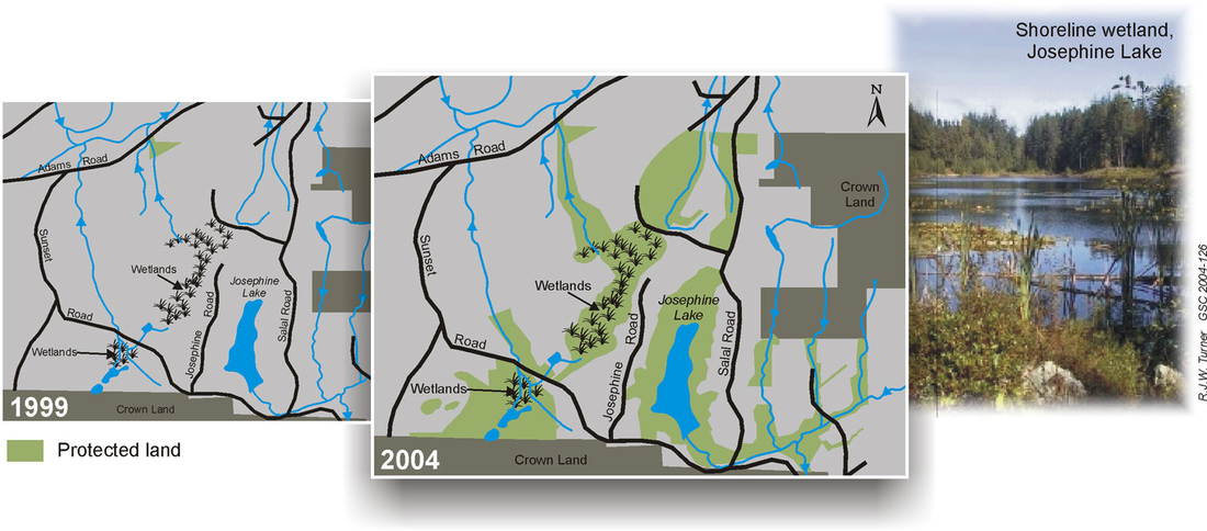
Protected Land
Image on the right: Shoreline wetland, Josephine Lake
(J.R.W. Turner GSC 2004-126)
Image on the right: Shoreline wetland, Josephine Lake
(J.R.W. Turner GSC 2004-126)
Waterscapes: