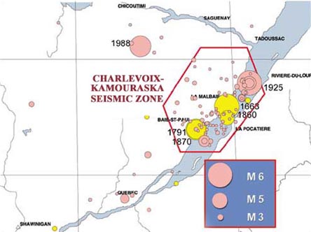
Historically, the epicentres of earthquakes felt strongly in the Québec region have been located in the Charlevoix/Kamouraska region and, to a lesser extent, in the Saguenay region. In 1663, 1791, 1860, 1870, and 1925, earthquakes with a magnitude greater than 6, with epicentres in the Charlevoix/Kamouraska region, strongly shook the city, causing damage and frightening citizens. In 1988, it was an earthquake in the Saguenay region that rattled the capital. But from time to time, milder tremors with epicentres closer to the city have also shaken the region without causing any appreciable damage.
Earthquakes felt in the Québec region. The yellow circles mark the locations of past earthquakes for which historical documents have been used to approximate the epicentres and magnitudes. The pink circles represent earthquakes whose epicentres and magnitudes have been calculated on the basis of instrument data. The years indicate the occurrence of the strongest earthquake in a given period of time. (Courtesy of GSC)
... or right beneath our feet
The vast majority of earthquakes in eastern Canada are caused by sudden movements along ancient faults associated with the St. Lawrence rift, a structure related to the basins of the Ottawa and Saguenay rivers. Although faults are found throughout the Canadian Shield, for reasons unknown only some are active. In the Charlevoix region, for example, the impact of an enormous meteorite some 350 million years ago may have helped to activate the faults in this region.
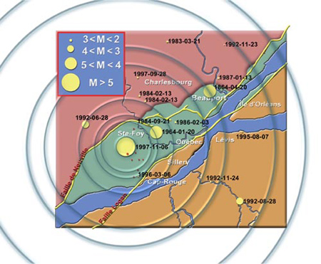
The Logan Fault is a major feature of the geology of the St. Lawrence valley, but we know now that it is not involved in the earthquakes that occur there. The Cap-Rouge earthquake of November 5, 1997, occurred at a depth of 22 km. Studies of the main shock and some 50 aftershocks enabled scientists to link this earthquake to reactivation at depth of a fracture in the Canadian Shield that may be the Neuville Fault.
Location of the epicentres of earthquakes originating in the Québec region. The red dots represent aftershocks from the Cap-Rouge earthquake. An earthquake must have a magnitude greater than 2.5 in order to be felt.
Certain Materials Amplify Vibrations
We have learned from strong earthquakes in the past that the extent of earthquake damage is often a function of the type of geological materials on which a building is constructed.
For example, given two similar buildings located at equal distances from the epicentre of an earthquake of magnitude 6, a building situated on thick deposits of clay or sand will be subject to more significant vibrations than one constructed on bedrock.
Such an amplification of seismic waves generally results in more significant damage, which explains why most of the destruction caused by earthquakes in the Québec area has occurred in parts of the Lower Town and the Port of Québec.
In the vicinity of steep inclines, the impact of an earthquake can vary. Along a rocky incline, rock falls may occur, while clay or sand slopes may be the setting for landslides.
