CGEN Archive

Waterscape Canada

CGEN's Home Page
  • Home
  • CGEN Minutes
  • EarthLinks
  • EdGEO
    • Bringing Earth Science to Life
    • Putting the Earth into Science
  • FBY
    • FBY-Chapter Previews
    • FBY-Sample Lesson
    • QMA-Apercus des chapitres
  • Geoscape
    • Geoscape Canada >
      • Calgary
      • Fort Fraser
      • Montreal
      • Nanaimo
      • Northwest Territories
      • Ottawa-Gatineau
      • Québec
      • Saskatchewan-North
      • Saskatchewan-South
      • Toronto
      • Vancouver
      • Victoria
      • Whitehorse
    • Géopanorama du Canada
    • Geoscape Posters
    • Geotours
    • Waterscapes >
      • Bowen Island
      • Bow River Basin
      • Gulf Islands
      • Okanagan Basin
  • Geovistas
  • Key Publications
    • Wat On Earth
  • OGGP
  • Contact Us

Waterscape - Gulf Islands

Hydropanoramas
  • Home
  • Location Map
  • Water Storage
  • Seasonal Precipitation
  • Water Conservation
  • Changing Climate
  • Water for Ecosystems
  • Water Underground
  • Protecting Our Water
  • Having enough...
  • Keeping it clean
  • Credits & Citation
  • Poster Downloads

Water Underground

Our deep storage: water underground
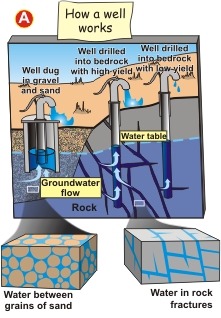
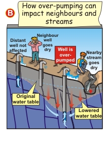
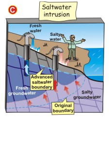
How groundwater works
A) How a well works
B) How over-pumping can impact neighbours and streams
C) Saltwater intrusion
Picture
Picture
Picture
Picture
Picture
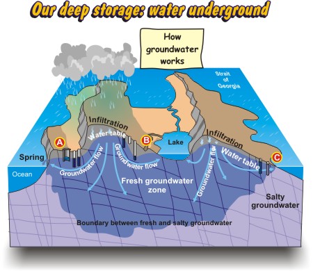
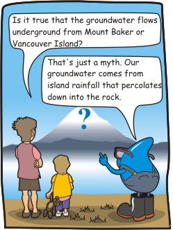
Is it true that the groundwater flows underground from Mount Baker or Vancouver Island? 
  • That's just a myth. Our groundwater comes from island rainfall that percolates down into the rock.
Waterscapes:
  • Bowen Island 
  • Bow River Basin
  • Gulf Islands
  • Okanagan Basin ​
Copyright CGEN 2014-2021
​ Quick Links to Earth Sciences Canada sites
​Earthlinks | WHERE Challenge | Careers in Earth Science |  Four Billion Years and Counting | IYPE | CFES | CGEN | IUGS | GeoVistas | OGGP