CGEN Archive
Waterscape Canada
CGEN's Home Page
Home
CGEN Minutes
EarthLinks
EdGEO
Bringing Earth Science to Life
Putting the Earth into Science
FBY
FBY-Chapter Previews
FBY-Sample Lesson
QMA-Apercus des chapitres
Geoscape
Geoscape Canada
>
Calgary
Fort Fraser
Montreal
Nanaimo
Northwest Territories
Ottawa-Gatineau
Québec
Saskatchewan-North
Saskatchewan-South
Toronto
Vancouver
Victoria
Whitehorse
Géopanorama du Canada
Geoscape Posters
Geotours
Waterscapes
>
Bowen Island
Bow River Basin
Gulf Islands
Okanagan Basin
Geovistas
Key Publications
Wat On Earth
OGGP
Contact Us
Waterscape -
Gulf Islands
Hydropanoramas
Home
Location Map
Water Storage
Seasonal Precipitation
Water Conservation
Changing Climate
Water for Ecosystems
Water Underground
Protecting Our Water
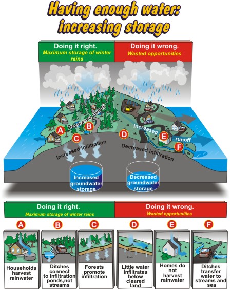
Having enough...
Keeping it clean
Credits & Citation
Poster Downloads
Having enough...
Doing it right. Maximum storage of winter rains
Households harvest rainwater
Ditches connect to infiltration ponds, not streams
Forests promote infiltration
Doing it wrong. Wasted opportunities
Little water infiltrates below cleared land
Homes do not harvest rainwater
Ditches transfer water to streams and sea
So how do islanders increase their water supplies?
We increase groundwater storage by maintaining our forest lands. And we harvest rainwater from our rooftops.
Waterscapes:
Bowen Island
Bow River Basin
Gulf Islands
Okanagan Basin