All of the road and rail traffic between Vancouver and the B.C. interior, as well as power transmission lines, gas pipelines, and fiber optic cables, pass through narrow mountain valleys: the Fraser Canyon; the Coquihalla which crosses high, avalanche-prone country; Highway 3, once blocked by the Hope Slide; and the Sea to Sky route via Squamish and Whistler. All of these corridors are vulnerable to blockage by landslides and avalanches, disrupting transportation, power, and communications to Vancouver.
Rockfalls in the Fraser Canyon
Rockfalls from steep faces have repeatedly disrupted the Trans-Canada Highway and derailed trains. Perhaps the most costly natural disaster in Canadian history was a rockfall at Hell's Gate in 1914 triggered by blasting on the CN rail line. The rockfall created an obstacle for migrating salmon that caused a dramatic decline in the Fraser River salmon fishery.
What Can Be Done?
Steep slopes can be made more stable by removing or bolting threatening rock. Slopes covered with metal mesh or sprayed with concrete prevent loosened rock from reaching the road or railway. Holes drilled into the slope allow groundwater to drain more easily, reducing water pressures that might trigger a rockfall.
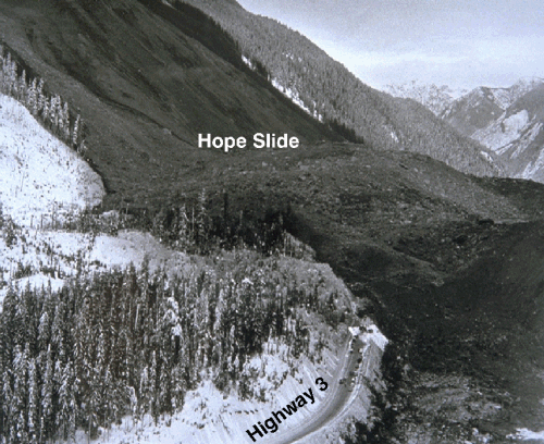
When a Mountain Fell
On January 9, 1965, a huge mass of rock fell from a mountain high above Highway 3 east of Hope. Four motorists were buried under tens of metres of blocky debris, enough to fill the BC Place football stadium many times. The landslide drove a wave of muddy debris high up the opposite valley wall.
What triggered the landslide is not known - there was neither unusual weather nor an earthquake at the time. Large landslides like the Hope Slide are far less common than rockfalls and debris flows, but are potentially far more destructive.
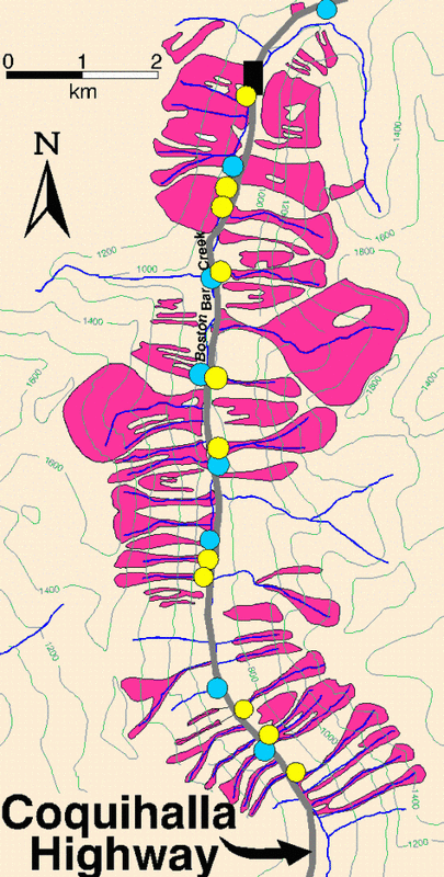
Avalanches Along The Coquihalla Highway
Deep snow accumulations on slopes can fail, triggering an avalanche. There are an average of 100 avalanches per year along the Coquihalla Highway southwest of the summit. Most are small and pose no threat to motorists, but some reach the highway.
The B.C. Government collects weather data throughout the winter, analyzes the stability of the snowpack, and issues avalanche forecasts at least once a day during hazardous periods. Dams, basins, mounds, and a snowshed have been built to stop or deflect avalanches, and explosives are used to bring down avalanches under controlled conditions.
Avalanche areas along a section of the Coquihalla Highway are shown in red on this map.