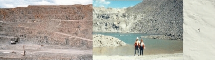
Figure 1a. Endako molydenum mine. (Photograph by L.C. Struik, GSC 1999-018A) Figure 1b. Waste rock dump in an abandoned pit of Endako molydenum
These are excavations and gravel, sand, silt and/or clay of variable thickness (referred to as diamicton) emplaced by human activity. Anthropogenic terrain extensive enough to be shown on this map occurs only at the Endako mine and includes open pits, tailings impoundments, and waste rock piles.
Peat Deposits
Figure 2a. Bog Southeast of Taltapin Lake (Photograph by A. Plouffe, GSC 1999-1999A) Figure 2b. Core of brown peat and grey clay. (Photograph by A. Plouffe, GSC 1999-019B.)
Organic peat and muck occur in bogs and swamps. The average thickness of organic deposits is 3 to 4 m, but the deposits can reach up to 11 m. The deposits are poor foundation material due to a low degree of consolidation and high water content. Bogs are a source of horticultural peat, although the resource has not been exploited in this region.
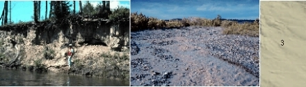
River Sediments
Figure 3a. Floodplain sand and silt, Nechako River (Photograph by A. Plouffe, GSC 1999-020) Figure 3b. Active alluvial fan. (Photograph by J.J. Clague.)
Well stratified to massive sand, gravel, and minor silt and clay underlie floodplains adjacent to streams throughout the area. The deposits are generally more than 2 m thick. Sand and gravel deposits above the ground water table may be mined for aggregate. Floodplains are good agricultural land but are prone to periodic flooding in the spring and after heavy rains, and have a shallow water table. The high permeability of the sand and gravel below the water table can form important aquifers. These aquifers are often vulnerable to surface contamination.
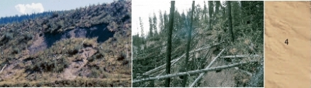
Landslide Debris
Figure 4a. Slump. (Photograph by V. Levson, GSC 1999-022A) Figure 4b. Headcarp of slump. (Photograph by V. Levson, GSC 1999-022B.)
Landslide deposits commonly occur on or at the base of unstable slopes. The texture and other properties of the sediment depend on the source materials and the type of landslide. The deposits are generally more than 3 m thick and have an irregular or hummocky surface. Landslides are most common along river-cut valleys, in terrain underlain by glacial lake sediments, such as the Nechako River valley. Nechako River has incised thick glacial lake silts forming unstable slopes.
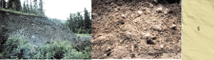
Slope Sediments
Figure 5a. Slope sediments exposed in scarp. (Photograph by A. Plouffe, GSC 1999-023A Figure 5b. Slope sediment. (Photograph by A. Plouffe, GSC 1999-023B.)
Poorly sorted sediment is deposited by slow gravitational movements and slopewash. The deposits are particularly common on steep slopes northwest of Trembleur Lake. Some slope deposits are a source of gravel for road construction.

