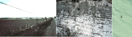
Figure 6a. Plain underlain by glacial lake sediment northwest of Vanderhoof (Photograph by A. Plouffe) Figure 6b. Layered glacial lake silts. (Photograph by J.J. Clague.)
Sand, silt, and minor clay deposited in lakes during the retreat of glaciers from the region occur in mainly two areas: a corridor which extends from Trembleur Lake to Stuart River; and the Endako-Nechako valleys. Steep slopes cut by streams into glacial lake sediments are prone to landsliding and these streams have a high risk of siltation. Glacial lake deposits form excellent agricultural land because they contain few stones, have high moisture retention, and occur as relatively flat surfaces.
Glacial River Sediments
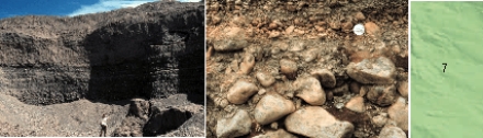
Figure 7a. Bedded sand and gravel north of Vanderhoof.(Photograph by A. Plouffe, GSC 1999-024B) Figure 7b. Gravel northeast of Fort St. James.(Photograph by L.C. Struik.)
Well sorted gravel and sand deposited by glacial meltwater streams occur mainly in the major valleys, but there are sporadic occurrences of glacial river sediments, too small to be shown on this map, on higher ground. These deposits are an excellent source of aggregate. Subsurface glacial river sediments are permeable and form large aquifers.
Glacial Till
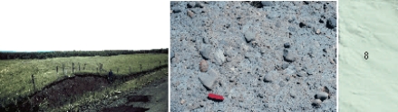
Figure 8a. Hummock till surface north of Burns Lake.(Photograph by A. Plouffe, GSC 1999-027) Figure 8b. Glacial till
Glacial till is sediment deposited directly by glaciers, consisting of boulders, cobbles, and pebbles in a matrix of sand, silt, and clay (referred to as "diamicton"). Till is generally compacted and is a good foundation material. Where the sediment has a high clay content, such as the Stuart Lake region, steep slopes can fail if saturated with water. Till in the northeast part of the map area contains abundant limestone, and groundwater in this region has high carbonate levels ("hard water"). Locally till derived through erosion by glaciers of mercury-rich bedrock is associated with faults in the Pinchi Lake region and contains high concentrations of mercury.
