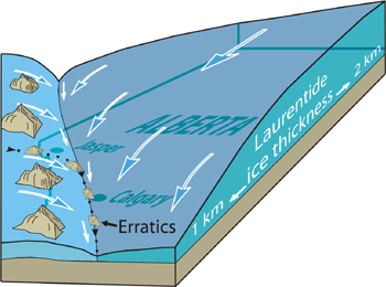
Over the last 2 million years, a series of cold episodes caused most of Canada to be covered by thick glacier ice. We currently live in the latest of several warm interglacial periods that occurred between these glacial episodes. During the most recent glacial episode, which peaked about 20 000 years ago, a huge ice sheet from central and northern Canada (Laurentide Ice Sheet) met with Cordilleran glaciers flowing eastward out of valleys in the Rocky Mountains. They met along a line that passes through Calgary.
Ice sheets meeting in Calgary
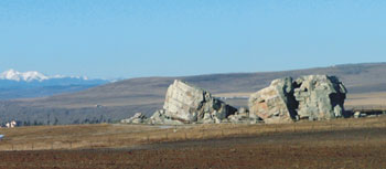
Erratics
Erratics are exceptionally large rocks carried long distances by glaciers. A string of them, the Foothills Erratics Train, marks the junction of the Laurentide and Cordilleran glaciers. It includes the Big Rock near Okotoks and boulders on Nose Hill and Paskapoo Slopes. They are rocks that fell from mountain walls near Jasper and were carried eastward out of the Rocky Mountains by valley glaciers, then as far south as northern Montana along the line where the Laurentide and Cordilleran ice sheets met.
The 'Big Rock' is an erratic from the Jasper area that now rests near Okotoks (Photo: B. Groulx)
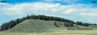
Drumlins
Another curious landform created by the glaciers is the drumlin. The best place to see drumlins is at Morley Flats, 42 km west of Calgary on the Trans-Canada Highway. Debate continues as to whether these asymmetric mounds form by deposition at the base of a glacier or by erosion by meltwaters flowing at the base of a glacier. In general, drumlins indicate the ice-flow direction: the steep ends point in the direction from which the ice flowed (upstream) and the gentle, tapered ends point downstream.
Drumlin north of the Trans-Canada Highway at Morley Flats (Photo: T. Poulton)
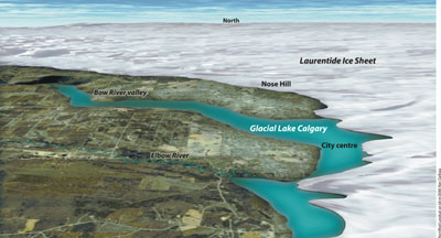
Glacial Lake Calgary
About 17 000 years, mountain ice that filled the Bow River valley began to melt and the eastern margin declined westward. Meltwater from the glacier were trapped by the Laurentide Ice Sheet in the center of Calgary, where they formed Glacial Lake Calgary. Fine sediments that were deposited in the lake are now the soil of much of the western part of Calgary. Mountain ice remnants remain today in the form of glaciers on the highest peaks of the Rocky Mountains.
Digital rendering of the Laurentide Ice Sheet on today's landscape (Rectified Landsat on 60 m DEM: Ron DaRoza)